Make a donation
Gear up for your next adventure:
As an Amazon Associate, this site earns from qualifying purchases at no extra cost to you.
Québec - Montréal - Saint-Laurent River - Lake Ontario - Niagara Falls
Interactive trail map
Make a donation
Gear up for your next adventure:
As an Amazon Associate, this site earns from qualifying purchases at no extra cost to you.
Trail profile
- Distance: 1,078.4 Km
- Elevation gain: 4,804 m
- Maximum elevation: 209 m
- Elevation loss: 4,632 m
- Minimum elevation: -1 m
Make a donation
Gear up for your next adventure:
As an Amazon Associate, this site earns from qualifying purchases at no extra cost to you.
About this trail
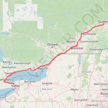
Name: Québec - Montréal - Saint-Laurent River - Lake Ontario - Niagara Falls trail, distance, elevation, map, profile, GPS track
Coordinates: 43.08778 -79.89248 46.82520 -71.19960
Topography: Quebec topographic map, elevation, terrain
Make a donation
Gear up for your next adventure:
As an Amazon Associate, this site earns from qualifying purchases at no extra cost to you.
Other hiking, mountain biking, running and outdoor activity trails
Click on a trail to view its statistics, map and profile.
Brockville - Cornwall
Canada > Ontario > Brockville > Brockville
#Bike
Distance: 100.0 Km • Elevation gain: 298 m • Maximum elevation: 102 m
Make a donation
Gear up for your next adventure:
As an Amazon Associate, this site earns from qualifying purchases at no extra cost to you.
Haliburton Forest
Canada > Ontario > Haliburton County > Dysart et al
#Hiking #Loop #Haliburton
Distance: 6.7 Km • Elevation gain: 59 m • Maximum elevation: 417 m
Mount Washington, Lion Head and Tuckerman Ravine Loop
United States > New Hampshire > Coos County
Loop hike from Pinkham Notch to Mount Washington via Tuckerman Ravine Trail, Crystal Cascades Falls and Lion Head Trail in the Pinkham Notch Scenic Area, the Mount Washington State Park and the White Mountain National Forest. #Hiking #Loop #Mountain #Nature #Forest #Falls #Park
Distance: 12.6 Km • Elevation gain: 1,325 m • Maximum elevation: 1,911 m
Make a donation
Gear up for your next adventure:
As an Amazon Associate, this site earns from qualifying purchases at no extra cost to you.
Serena Gundy Park
Distance: 1.3 Km • Elevation gain: 29 m • Maximum elevation: 129 m
Make a donation
Gear up for your next adventure:
As an Amazon Associate, this site earns from qualifying purchases at no extra cost to you.
Aldershot - Kitchener
Canada > Ontario > Halton Region > Burlington
#Bike
Distance: 79.0 Km • Elevation gain: 570 m • Maximum elevation: 346 m
Berthierville - Trois-Rivières
Canada > Quebec > D'Autray > Berthierville
#Bike
Distance: 72.7 Km • Elevation gain: 161 m • Maximum elevation: 41 m
Belleville - Kingston
Canada > Ontario > Belleville > Belleville
#Bike
Distance: 92.7 Km • Elevation gain: 394 m • Maximum elevation: 115 m
Make a donation
Gear up for your next adventure:
As an Amazon Associate, this site earns from qualifying purchases at no extra cost to you.
Cobourg - Belleville
Canada > Ontario > Northumberland County > Cobourg
#Bike
Distance: 81.5 Km • Elevation gain: 286 m • Maximum elevation: 118 m
Oshawa - Cobourg
Canada > Ontario > Durham Region > Oshawa
#Bike
Distance: 66.7 Km • Elevation gain: 453 m • Maximum elevation: 130 m
Make a donation
Gear up for your next adventure:
As an Amazon Associate, this site earns from qualifying purchases at no extra cost to you.
Make a donation
Gear up for your next adventure:
As an Amazon Associate, this site earns from qualifying purchases at no extra cost to you.
Pierreville - Leclercville
Canada > Quebec > Urban agglomeration of Montreal > Montreal
#Bike #Pierreville #Leclercville #Atlantic
Distance: 120.8 Km • Elevation gain: 324 m • Maximum elevation: 36 m
Make a donation
Gear up for your next adventure:
As an Amazon Associate, this site earns from qualifying purchases at no extra cost to you.
Make a donation
Gear up for your next adventure:
As an Amazon Associate, this site earns from qualifying purchases at no extra cost to you.
Cobourg - Adolphustown
Canada > Ontario > Northumberland County > Cobourg
Lake Ontario. #Bike #Cobourg #Adolphustown #Ontario
Distance: 114.3 Km • Elevation gain: 449 m • Maximum elevation: 119 m
Lanoraie - Trois-Rivières
Canada > Quebec > D'Autray > Lanoraie
Saint Lawrence River. #Bike #Lanoraie #TroisRivières #SaintLawrence
Distance: 71.5 Km • Elevation gain: 122 m • Maximum elevation: 21 m
Mattawa - Stonecliffe
Canada > Ontario > Nipissing District > Mattawa
Distance: 73.7 Km • Elevation gain: 903 m • Maximum elevation: 318 m
Make a donation
Gear up for your next adventure:
As an Amazon Associate, this site earns from qualifying purchases at no extra cost to you.
Round Top - Sutton Trail
Canada > Quebec > Brome-Missisquoi > Sutton
Sutton Natural Environment Park. #Hiking #Snowshoeing #Sutton
Distance: 6.1 Km • Elevation gain: 422 m • Maximum elevation: 944 m
Arkon Lake Loop
Canada > Ontario > Frontenac County > South Frontenac
Frontenac Provincial Park. #Hiking #Snowshoeing #Loop #Frontenac
Distance: 9.8 Km • Elevation gain: 123 m • Maximum elevation: 191 m
Friday Harbour Nature Reserve
Canada > Ontario > Simcoe County > Innisfil
#Hiking #MTB #Snowshoeing #Loop #FridayHarbour
Distance: 4.6 Km • Elevation gain: 22 m • Maximum elevation: 241 m
Make a donation
Gear up for your next adventure:
As an Amazon Associate, this site earns from qualifying purchases at no extra cost to you.
Stoney Creek Loop
Stoney Creek Conservation Area. #Hiking #MTB #Running #Snowshoeing #Loop #StoneyCreek
Distance: 3.9 Km • Elevation gain: 19 m • Maximum elevation: 116 m
Bruce Trail from Guelph Line
Canada > Ontario > Halton Region > Burlington
Distance: 5.4 Km • Elevation gain: 119 m • Maximum elevation: 270 m
Make a donation
Gear up for your next adventure:
As an Amazon Associate, this site earns from qualifying purchases at no extra cost to you.
Big Slide Mountain Loop
United States > New York > Essex County > Town of Keene
Lop hike from Garden Parking to Big Slide Mountain via Phelps Trail, Big Slide Trail, The Brothers Trail, Third Brother, Second Brother and First Brother in the High Peaks Wilderness. #Hiking #Loop #Mountain #Nature #Wilderness
Distance: 14.5 Km • Elevation gain: 855 m • Maximum elevation: 1,252 m
Little Haystack Mountain, Mount Lincoln and Mount Lafayette Loop
United States > New Hampshire > Grafton County > Lincoln
Loop hike from Franconia Notch via Falling Waters Trail, Stairs Falls, Swiftwater Falls, Cloudland Falls, Little Haystack Mountain, Franconia Ridge Trail, Mount Lincoln, Mount Lafayette, Greenleaf Trail, Greenleaf Hut and Old Bridle Path in the Franconia Notch State Park and the White Mountain National Forest.…
Distance: 13.1 Km • Elevation gain: 1,146 m • Maximum elevation: 1,582 m
Mount Skylight
United States > New York > Essex County
Hike to Mount Skylight via Adirondack Loj Road, Heart Lake, Van Hoevenberg Trail, Marcy Dam, Avalanche Pass Trail, Avalanche Camp, Lake Arnold Trail, Lake Arnold, Mount Marcy Trail, Lake Tear of the Clouds, Four Corners and Skylight Trail in the High Peaks Wilderness and the Adirondack Park. #Hiking #Mountain…
Distance: 33.0 Km • Elevation gain: 1,295 m • Maximum elevation: 1,492 m
Make a donation
Gear up for your next adventure:
As an Amazon Associate, this site earns from qualifying purchases at no extra cost to you.
Mount Pisgah via South Trail and Pulpit Rock in Willoughby State Forest
United States > Vermont > Orleans County > Westmore
The hike to Mount Pisgah is a rewarding journey with iconic views. As you ascend, Pulpit Rock provides a dramatic viewpoint perched hundreds of feet above the stunning Lake Willoughby, framed by the rugged cliffs of nearby Mount Hor. The summit reveals panoramic vistas that stretch across the Northeast…
Distance: 7.4 Km • Elevation gain: 710 m • Maximum elevation: 831 m
Mount Lafayette Loop via Franconia Ridge Trail in White Mountain National Forest
United States > New Hampshire > Grafton County > Lincoln
The Mount Lafayette Loop is a challenging and rewarding hike, offering some of the most stunning views in the region. Starting at the Falling Waters Trail, the hike begins with a steep ascent through the forest, passing several picturesque waterfalls. The real highlight, however, comes as you reach the…
Distance: 13.2 Km • Elevation gain: 1,118 m • Maximum elevation: 1,582 m
Bald Mountain and Artists Bluff Loop Trail in Franconia Notch State Park
United States > New Hampshire > Grafton County > Franconia
The Bald Mountain and Artists Bluff Loop Trail in Franconia Notch State Park offers hikers a rewarding experience with panoramic vistas. From the summit of Bald Mountain, enjoy expansive views of Echo Lake and the surrounding White Mountains. Continuing along the trail, Artists Bluff provides a unique vantage…
Distance: 2.4 Km • Elevation gain: 111 m • Maximum elevation: 696 m
Make a donation
Gear up for your next adventure:
As an Amazon Associate, this site earns from qualifying purchases at no extra cost to you.
Old mills to humber bay park
Distance: 12.4 Km • Elevation gain: 75 m • Maximum elevation: 96 m
Lake Muskoka - Lake Rosseau
Canada > Ontario > Muskoka District > Gravenhurst
#Bike
Distance: 105.5 Km • Elevation gain: 1,294 m • Maximum elevation: 344 m
Trois-Rivières - Québec
Canada > Quebec > Trois-Rivières
#Bike
Distance: 138.5 Km • Elevation gain: 838 m • Maximum elevation: 108 m
Make a donation
Gear up for your next adventure:
As an Amazon Associate, this site earns from qualifying purchases at no extra cost to you.
Montréal - Berthierville
Canada > Quebec > Urban agglomeration of Montreal > Montreal
#Bike
Distance: 71.1 Km • Elevation gain: 133 m • Maximum elevation: 41 m
Salaberry-de-Valleyfield - Montréal
Canada > Quebec > Beauharnois-Salaberry > Salaberry-de-Valleyfield
#Bike
Distance: 89.9 Km • Elevation gain: 363 m • Maximum elevation: 70 m
Make a donation
Gear up for your next adventure:
As an Amazon Associate, this site earns from qualifying purchases at no extra cost to you.
Toronto - Oshawa
Canada > Ontario > Old Toronto
#Bike
Distance: 67.3 Km • Elevation gain: 457 m • Maximum elevation: 183 m
Hamilton - Toronto
#Bike
Distance: 81.3 Km • Elevation gain: 458 m • Maximum elevation: 111 m
Niagara Falls - Hamilton
Canada > Ontario > Niagara Region > Niagara Falls
#Bike
Distance: 84.1 Km • Elevation gain: 537 m • Maximum elevation: 209 m
Make a donation
Gear up for your next adventure:
As an Amazon Associate, this site earns from qualifying purchases at no extra cost to you.
Georgian Bay Islands National Park
Canada > Ontario > Muskoka District > Georgian Bay Township
Lake Huron. Beausoleil Island. #Hiking #Loop #Georgian #Beausoleil #Huron
Distance: 8.0 Km • Elevation gain: 61 m • Maximum elevation: 195 m
Make a donation
Gear up for your next adventure:
As an Amazon Associate, this site earns from qualifying purchases at no extra cost to you.
Make a donation
Gear up for your next adventure:
As an Amazon Associate, this site earns from qualifying purchases at no extra cost to you.
Burlington - Hamilton
Canada > Ontario > Halton Region > Burlington
Waterfront Trail. Lake Ontario. #Bike #Waterfront #Ontario
Distance: 12.1 Km • Elevation gain: 50 m • Maximum elevation: 82 m
Brockville - Ottawa
Canada > Ontario > Brockville > Brockville
#Bike #Brockville #Ottawa
Distance: 118.4 Km • Elevation gain: 375 m • Maximum elevation: 134 m
Make a donation
Gear up for your next adventure:
As an Amazon Associate, this site earns from qualifying purchases at no extra cost to you.
East Hawkesbury - Montréal
Canada > Ontario > Prescott and Russell Counties > East Hawkesbury
#Bike #EastHawkesbury #Montréal
Distance: 91.4 Km • Elevation gain: 393 m • Maximum elevation: 91 m
Wasaga Beach - Orillia
Canada > Ontario > Simcoe County > Wasaga Beach
Distance: 81.4 Km • Elevation gain: 450 m • Maximum elevation: 343 m
Make a donation
Gear up for your next adventure:
As an Amazon Associate, this site earns from qualifying purchases at no extra cost to you.
Brockville - Lancaster
Canada > Ontario > Brockville > Brockville
Saint-Laurent River. #Bike #SaintLaurent
Distance: 135.3 Km • Elevation gain: 489 m • Maximum elevation: 101 m
Scarborough - Cobourg
Lake Ontario. #Bike #Scarborough #Cobourg #Toronto #Ontario
Distance: 107.4 Km • Elevation gain: 717 m • Maximum elevation: 130 m
Brampton - Scarborough
Canada > Ontario > Peel Region > Brampton
Lake Ontario. #Bike #Brampton #Scarborough #Toronto #Ontario
Distance: 73.2 Km • Elevation gain: 570 m • Maximum elevation: 184 m
Orangeville - Brampton
Canada > Ontario > Dufferin County > Mono
Distance: 54.8 Km • Elevation gain: 206 m • Maximum elevation: 461 m
Make a donation
Gear up for your next adventure:
As an Amazon Associate, this site earns from qualifying purchases at no extra cost to you.
Québec - Saint-Jean-Port-Joli
Canada > Quebec > Urban agglomeration of Québec > Quebec
Saint Lawrence River. #Bike #Québec #SaintJeanPortJoli
Distance: 95.2 Km • Elevation gain: 476 m • Maximum elevation: 82 m
Portneuf - Québec
Canada > Quebec > Portneuf (MRC) > Portneuf
Saint Lawrence River. #Bike #Portneuf #Québec #SaintLawrence
Distance: 66.8 Km • Elevation gain: 547 m • Maximum elevation: 90 m
Make a donation
Gear up for your next adventure:
As an Amazon Associate, this site earns from qualifying purchases at no extra cost to you.
Trois-Rivières - Portneuf
Canada > Quebec > Trois-Rivières
Saint Lawrence River. #Bike #TroisRivières #Portneuf #SaintLawrence
Distance: 67.6 Km • Elevation gain: 211 m • Maximum elevation: 44 m
Montréal - Lanoraie
Canada > Quebec > Urban agglomeration of Montreal > Montreal
Saint Lawrence River. #Bike #Montréal #Lanoraie #SaintLawrence
Distance: 70.1 Km • Elevation gain: 181 m • Maximum elevation: 52 m
Ottawa - Grenville-sur-la-Rouge
Canada > Ontario > (Old) Ottawa
Ottawa River. #Bike #Ottawa #GrenvilleSurLaRouge
Distance: 93.5 Km • Elevation gain: 330 m • Maximum elevation: 73 m
Make a donation
Gear up for your next adventure:
As an Amazon Associate, this site earns from qualifying purchases at no extra cost to you.
Make a donation
Gear up for your next adventure:
As an Amazon Associate, this site earns from qualifying purchases at no extra cost to you.
Joker's Hill Loop
Canada > Ontario > York Region > Newmarket
Thornton Bales Conservation Area. #Hiking #Running #Loop #ThorntonBales
Distance: 2.9 Km • Elevation gain: 50 m • Maximum elevation: 324 m
Make a donation
Gear up for your next adventure:
As an Amazon Associate, this site earns from qualifying purchases at no extra cost to you.