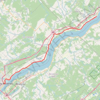
Trois-Rivières - Portneuf
Saint Lawrence River. #Bike #TroisRivières #Portneuf #SaintLawrence
- Distance: 67.6 Km
- Elevation gain: 211 m
- Maximum elevation: 44 m
- Elevation loss: 220 m
- Minimum elevation: 4 m
Interactive trail map
Trail profile
- Distance: 67.6 Km
- Elevation gain: 211 m
- Maximum elevation: 44 m
- Elevation loss: 220 m
- Minimum elevation: 4 m
About this trail
Name: Trois-Rivières - Portneuf trail, distance, elevation, map, profile, GPS track
Start: 501, Rue Radisson, Trois-Rivières, Mauricie, Quebec, G9A 2C7, Canada (46.34369 -72.54498)
Coordinates: 46.34155 -72.54587 46.65317 -71.92735
Topography: Trois-Rivières topographic map, elevation, terrain
Other hiking, mountain biking, running and outdoor activity trails
Click on a trail to view its statistics, map and profile.
Lanoraie - Trois-Rivières
Canada > Quebec > D'Autray > Lanoraie
Saint Lawrence River. #Bike #Lanoraie #TroisRivières #SaintLawrence
Distance: 71.5 Km • Elevation gain: 122 m • Maximum elevation: 21 m
Trois-Rivières - Québec
Canada > Quebec > Trois-Rivières
#Bike
Distance: 138.5 Km • Elevation gain: 838 m • Maximum elevation: 108 m