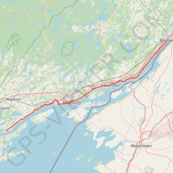
Adolphustown - Brockville
Interactive trail map
Trail profile
- Distance: 131.4 Km
- Elevation gain: 691 m
- Maximum elevation: 111 m
- Elevation loss: 686 m
- Minimum elevation: 74 m
About this trail
Name: Adolphustown - Brockville trail, distance, elevation, map, profile, GPS track
Coordinates: 44.06109 -77.00663 44.57772 -75.70213
Topography: Lennox and Addington County topographic map, elevation, terrain
Other hiking, mountain biking, running and outdoor activity trails
Click on a trail to view its statistics, map and profile.
Arkon Lake Loop
Canada > Ontario > Frontenac County > South Frontenac
Frontenac Provincial Park. #Hiking #Snowshoeing #Loop #Frontenac
Distance: 9.8 Km • Elevation gain: 123 m • Maximum elevation: 191 m
Cobourg - Adolphustown
Canada > Ontario > Northumberland County > Cobourg
Lake Ontario. #Bike #Cobourg #Adolphustown #Ontario
Distance: 114.3 Km • Elevation gain: 449 m • Maximum elevation: 119 m
Brockville - Lancaster
Canada > Ontario > Brockville > Brockville
Saint-Laurent River. #Bike #SaintLaurent
Distance: 135.3 Km • Elevation gain: 489 m • Maximum elevation: 101 m
Brockville - Ottawa
Canada > Ontario > Brockville > Brockville
#Bike #Brockville #Ottawa
Distance: 118.4 Km • Elevation gain: 375 m • Maximum elevation: 134 m
Belleville - Kingston
Canada > Ontario > Belleville > Belleville
#Bike
Distance: 92.7 Km • Elevation gain: 394 m • Maximum elevation: 115 m
Waypoints_19-JUL-23
United States > New York > Jefferson County > Millen Bay
Distance: 0.5 Km • Elevation gain: 2 m • Maximum elevation: 78 m