Make a donation
Gear up for your next adventure:
As an Amazon Associate, this site earns from qualifying purchases at no extra cost to you.
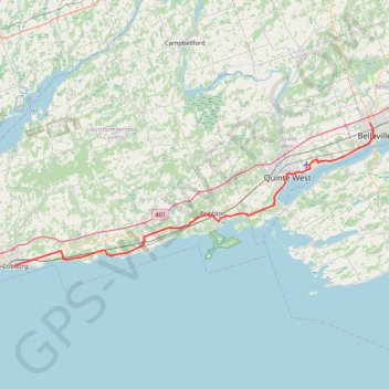
Cobourg - Belleville
#Bike
- Distance: 81.5 Km
- Elevation gain: 286 m
- Maximum elevation: 118 m
- Elevation loss: 269 m
- Minimum elevation: 74 m
Interactive trail map
Make a donation
Gear up for your next adventure:
As an Amazon Associate, this site earns from qualifying purchases at no extra cost to you.
Trail profile
- Distance: 81.5 Km
- Elevation gain: 286 m
- Maximum elevation: 118 m
- Elevation loss: 269 m
- Minimum elevation: 74 m
Make a donation
Gear up for your next adventure:
As an Amazon Associate, this site earns from qualifying purchases at no extra cost to you.
About this trail
Name: Cobourg - Belleville trail, distance, elevation, map, profile, GPS track
End: 285, North Front Street, Belleville, Central Ontario, Ontario, K8P 3C4, Canada (44.18358 -77.39401)
Coordinates: 43.95850 -78.16858 44.18358 -77.38501
Topography: Northumberland County topographic map, elevation, terrain
Make a donation
Gear up for your next adventure:
As an Amazon Associate, this site earns from qualifying purchases at no extra cost to you.
Other hiking, mountain biking, running and outdoor activity trails
Click on a trail to view its statistics, map and profile.
Scarborough - Cobourg
Lake Ontario. #Bike #Scarborough #Cobourg #Toronto #Ontario
Distance: 107.4 Km • Elevation gain: 717 m • Maximum elevation: 130 m
Cobourg - Adolphustown
Canada > Ontario > Northumberland County > Cobourg
Lake Ontario. #Bike #Cobourg #Adolphustown #Ontario
Distance: 114.3 Km • Elevation gain: 449 m • Maximum elevation: 119 m
Batawa Trails
Canada > Ontario > Quinte West > Batawa
#Hiking #MTB #Snowshoeing #Loop
Distance: 3.1 Km • Elevation gain: 70 m • Maximum elevation: 153 m
Make a donation
Gear up for your next adventure:
As an Amazon Associate, this site earns from qualifying purchases at no extra cost to you.
Belleville - Kingston
Canada > Ontario > Belleville > Belleville
#Bike
Distance: 92.7 Km • Elevation gain: 394 m • Maximum elevation: 115 m
Oshawa - Cobourg
Canada > Ontario > Durham Region > Oshawa
#Bike
Distance: 66.7 Km • Elevation gain: 453 m • Maximum elevation: 130 m
Walk - Belleville Shoreline
Canada > Ontario > Belleville > Belleville
Canada, ON, Belleville
Distance: 3.8 Km • Elevation gain: 21 m • Maximum elevation: 96 m
Walk - Trent River
Canada > Ontario > Quinte West
Canada, ON, Trenton Quinte West
Distance: 5.4 Km • Elevation gain: 26 m • Maximum elevation: 86 m
Make a donation
Gear up for your next adventure:
As an Amazon Associate, this site earns from qualifying purchases at no extra cost to you.
Zwick's Island Park
Canada > Ontario > Belleville > Belleville
Distance: 0.9 Km • Elevation gain: 5 m • Maximum elevation: 81 m