Thank you for supporting this site ❤️
Make a donation
Make a donation
Gear up for your next adventure:
As an Amazon Associate, this site earns from qualifying purchases at no extra cost to you.
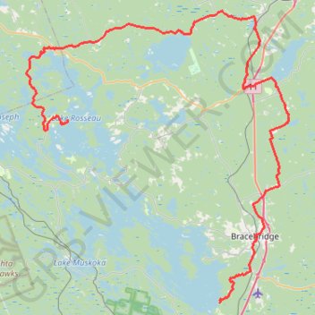
Lake Muskoka - Lake Rosseau
#Bike
- Distance: 105.5 Km
- Elevation gain: 1,294 m
- Maximum elevation: 344 m
- Elevation loss: 1,296 m
- Minimum elevation: 223 m
Interactive trail map
Thank you for supporting this site ❤️
Make a donation
Make a donation
Gear up for your next adventure:
As an Amazon Associate, this site earns from qualifying purchases at no extra cost to you.
Trail profile
- Distance: 105.5 Km
- Elevation gain: 1,294 m
- Maximum elevation: 344 m
- Elevation loss: 1,296 m
- Minimum elevation: 223 m
Thank you for supporting this site ❤️
Make a donation
Make a donation
Gear up for your next adventure:
As an Amazon Associate, this site earns from qualifying purchases at no extra cost to you.
About this trail
Name: Lake Muskoka - Lake Rosseau trail, distance, elevation, map, profile, GPS track
Coordinates: 44.96372 -79.68444 45.29987 -79.25529
Topography: Muskoka District topographic map, elevation, terrain
Thank you for supporting this site ❤️
Make a donation
Make a donation
Gear up for your next adventure:
As an Amazon Associate, this site earns from qualifying purchases at no extra cost to you.
Other hiking, mountain biking, running and outdoor activity trails
Click on a trail to view its statistics, map and profile.