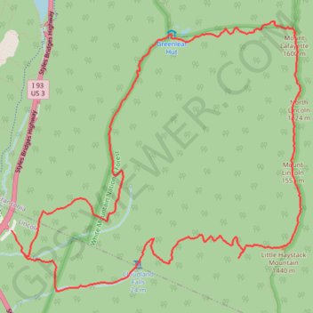
Mount Lafayette Loop
The Mount Lafayette Loop begins in Franconia Notch, at the edge of the White Mountain National Forest, and climbs away from the parkway into shaded hardwood and spruce forest. The route follows the Falling Waters side of the loop beside Walker Brook and Dry Brook, passing Stairs Falls and Cloudland Falls as the trail becomes rockier and more mountain-like.
Above the waterfalls, the itinerary rises toward the open crest of Franconia Ridge, reaching Little Haystack Mountain before following the Appalachian Trail section of the ridge toward Mount Lincoln and Mount Lafayette. This high traverse is the scenic heart of the loop, with broad views over Franconia Notch, the Pemigewasset Wilderness, the Kinsman Range, and the surrounding White Mountains.
From Mount Lafayette, the route leaves the ridge on the Greenleaf Trail, descending past rocky alpine slopes to Greenleaf Hut, set below the summit in a dramatic mountain basin. The return follows the Old Bridle Path through forested ridges and brookside terrain, gradually closing the loop back toward Lafayette Place and the starting area.
#Hiking #Snowshoeing #Mountain #Forest #Waterfall #River #Nature #Ridge #Summit #Wilderness
- Distance: 13.5 Km
- Elevation gain: 1,138 m
- Maximum elevation: 1,582 m
- Elevation loss: 1,138 m
- Minimum elevation: 547 m
Interactive trail map
Trail profile
- Distance: 13.5 Km
- Elevation gain: 1,138 m
- Maximum elevation: 1,582 m
- Elevation loss: 1,138 m
- Minimum elevation: 547 m
About this trail
Name: Mount Lafayette Loop trail, distance, elevation, map, profile, GPS track
Coordinates: 44.13625 -71.68125 44.16166 -71.64348
Other hiking, mountain biking, running and outdoor activity trails
Click on a trail to view its statistics, map and profile.
Mount Lafayette Loop via Franconia Ridge Trail in White Mountain National Forest
United States > New Hampshire > Grafton County > Lincoln
The Mount Lafayette Loop is a challenging and rewarding hike, offering some of the most stunning views in the region. Starting at the Falling Waters Trail, the hike begins with a steep ascent through the forest, passing several picturesque waterfalls. The real highlight, however, comes as you reach the…
Distance: 13.2 Km • Elevation gain: 1,118 m • Maximum elevation: 1,582 m
Little Haystack Mountain, Mount Lincoln and Mount Lafayette Loop
United States > New Hampshire > Grafton County > Lincoln
Loop hike from Franconia Notch via Falling Waters Trail, Stairs Falls, Swiftwater Falls, Cloudland Falls, Little Haystack Mountain, Franconia Ridge Trail, Mount Lincoln, Mount Lafayette, Greenleaf Trail, Greenleaf Hut and Old Bridle Path in the Franconia Notch State Park and the White Mountain National Forest.…
Distance: 13.1 Km • Elevation gain: 1,146 m • Maximum elevation: 1,582 m