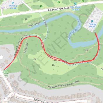
Import a GPX file
👉 Easily get elevation data in JSON, GeoTIFF and KML formats using Elevation API
Thank you for supporting this site ❤️
Make a donation

Gear up for your next adventure:

As an Amazon Associate, this site earns from qualifying purchases at no extra cost to you.

Serena Gundy Park

#Hiking #Running #SerenaGundy

  • Distance: 1.3 Km
  • Elevation gain: 29 m
  • Maximum elevation: 129 m
  • Elevation loss: 29 m
  • Minimum elevation: 105 m

Interactive trail map

Gear up for your next adventure:

As an Amazon Associate, this site earns from qualifying purchases at no extra cost to you.

Trail profile

👉 Easily get elevation data in JSON, GeoTIFF and KML formats using Elevation API
Thank you for supporting this site ❤️
Make a donation

Gear up for your next adventure:

As an Amazon Associate, this site earns from qualifying purchases at no extra cost to you.

About this trail

Other hiking, mountain biking, running and outdoor activity trails

Click on a trail to view its statistics, map and profile.

Québec - Montréal - Saint-Laurent River - Lake Ontario - Niagara Falls

Canada > Quebec > Urban agglomeration of Québec > Quebec

#Bike #Ontario

Distance: 1,078.4 Km • Elevation gain: 4,804 m • Maximum elevation: 209 m

Toronto - Oshawa

Canada > Ontario > Old Toronto

#Bike

Distance: 67.3 Km • Elevation gain: 457 m • Maximum elevation: 183 m

Toronto loop

Canada > Ontario > Old Toronto

#Bike #Loop #Toronto

Distance: 81.4 Km • Elevation gain: 661 m • Maximum elevation: 205 m

Brampton - Scarborough

Canada > Ontario > Peel Region > Brampton

Lake Ontario. #Bike #Brampton #Scarborough #Toronto #Ontario

Distance: 73.2 Km • Elevation gain: 570 m • Maximum elevation: 184 m

Gear up for your next adventure:

Camping Coffee Maker - Brew fresh coffee anywhere on the topographic map
🚲Handlebar Phone Mount - View topographic-map.com live while cycling
🥾Trail Running Boots - Durable shoes designed for trail running

As an Amazon Associate, this site earns from qualifying purchases at no extra cost to you.