Thank you for supporting this site ❤️
Make a donation
Make a donation
Gear up for your next adventure:
As an Amazon Associate, this site earns from qualifying purchases at no extra cost to you.
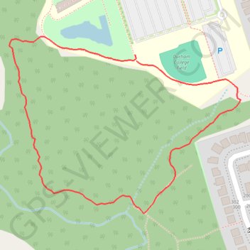
Cedar Valley Walk
Interactive trail map
Thank you for supporting this site ❤️
Make a donation
Make a donation
Gear up for your next adventure:
As an Amazon Associate, this site earns from qualifying purchases at no extra cost to you.
Trail profile
- Distance: 1.3 Km
- Elevation gain: 16 m
- Maximum elevation: 149 m
- Elevation loss: 16 m
- Minimum elevation: 133 m
- Moving time: 19 m 59 s
- Moving speed: 3.8 Km/h
- Maximum speed: 6.0 Km/h
- Total time: 20 m 29 s
- Global speed: 3.7 Km/h
Thank you for supporting this site ❤️
Make a donation
Make a donation
Gear up for your next adventure:
As an Amazon Associate, this site earns from qualifying purchases at no extra cost to you.
About this trail
Name: Cedar Valley Walk trail, distance, elevation, map, profile, GPS track
Coordinates: 43.93787 -78.89834 43.94073 -78.89315
Topography: Oshawa topographic map, elevation, terrain
Thank you for supporting this site ❤️
Make a donation
Make a donation
Gear up for your next adventure:
As an Amazon Associate, this site earns from qualifying purchases at no extra cost to you.
Other hiking, mountain biking, running and outdoor activity trails
Click on a trail to view its statistics, map and profile.
Scarborough - Cobourg
Lake Ontario. #Bike #Scarborough #Cobourg #Toronto #Ontario
Distance: 107.4 Km • Elevation gain: 717 m • Maximum elevation: 130 m