Thank you for supporting this site ❤️
Make a donation
Make a donation
Gear up for your next adventure:
As an Amazon Associate, this site earns from qualifying purchases at no extra cost to you.
North Bay - Mattawa
Interactive trail map
Thank you for supporting this site ❤️
Make a donation
Make a donation
Gear up for your next adventure:
As an Amazon Associate, this site earns from qualifying purchases at no extra cost to you.
Trail profile
- Distance: 63.4 Km
- Elevation gain: 455 m
- Maximum elevation: 272 m
- Elevation loss: 513 m
- Minimum elevation: 147 m
Thank you for supporting this site ❤️
Make a donation
Make a donation
Gear up for your next adventure:
As an Amazon Associate, this site earns from qualifying purchases at no extra cost to you.
About this trail
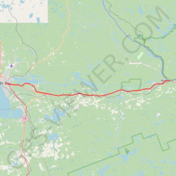
Name: North Bay - Mattawa trail, distance, elevation, map, profile, GPS track
Coordinates: 46.26754 -79.43899 46.31842 -78.69056
Topography: North Bay topographic map, elevation, terrain
Thank you for supporting this site ❤️
Make a donation
Make a donation
Gear up for your next adventure:
As an Amazon Associate, this site earns from qualifying purchases at no extra cost to you.
Other hiking, mountain biking, running and outdoor activity trails
Click on a trail to view its statistics, map and profile.
Mattawa - Stonecliffe
Canada > Ontario > Nipissing District > Mattawa
Distance: 73.7 Km • Elevation gain: 903 m • Maximum elevation: 318 m