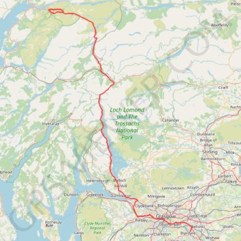
Munro hillwalk Meall Dearg Sgorr nam Fiannaidh Aonach Eagach
Interactive trail map
Trail profile
- Distance: 173.4 Km
- Elevation gain: 2,915 m
- Maximum elevation: 962 m
- Elevation loss: 3,056 m
- Minimum elevation: 0 m
About this trail
Name: Munro hillwalk Meall Dearg Sgorr nam Fiannaidh Aonach Eagach trail, distance, elevation, map, profile, GPS track
Start: A82, Highland, Scotland, PH50 4RL, United Kingdom (56.66661 -4.98214)
Coordinates: 55.79780 -5.08355 56.68145 -4.06083
Other hiking, mountain biking, running and outdoor activity trails
Click on a trail to view its statistics, map and profile.
Paths around Drumclog Moor
United Kingdom > Scotland > East Dunbartonshire > Milngavie
Distance: 3.1 Km • Elevation gain: 51 m • Maximum elevation: 120 m
Trails in and around Mugdock Country Park
United Kingdom > Scotland > Stirling > Blanefield > Craigallian
Distance: 2.9 Km • Elevation gain: 37 m • Maximum elevation: 180 m
Bowling Basin Loop Walk
United Kingdom > Scotland > West Dunbartonshire > Bowling
Distance: 1.8 Km • Elevation gain: 19 m • Maximum elevation: 13 m
Mugdock Country Park Walk
United Kingdom > Scotland > Stirling > Blanefield > Craigallian
Distance: 3.3 Km • Elevation gain: 36 m • Maximum elevation: 178 m
Pheasants's Wood Loop in Mugdock Country Park
United Kingdom > Scotland > Stirling > Blanefield > Craigallian
Distance: 1.2 Km • Elevation gain: 15 m • Maximum elevation: 178 m
Loop Walk at Mugdock Country Park
United Kingdom > Scotland > Stirling > Mugdock
Distance: 2.7 Km • Elevation gain: 35 m • Maximum elevation: 172 m
Roads and trails in Clydebank and Drumchapel
United Kingdom > Scotland > Glasgow City > Glasgow
Distance: 11.5 Km • Elevation gain: 97 m • Maximum elevation: 46 m
Jaw Reservoir, Cochno Hill and Greenside Reservoir in Kilpatrick Hills
United Kingdom > Scotland > West Dunbartonshire > Faifley
Distance: 9.6 Km • Elevation gain: 276 m • Maximum elevation: 342 m
Dumgoyne Loop Trail
United Kingdom > Scotland > Stirling > Dumgoyne
Distance: 5.2 Km • Elevation gain: 394 m • Maximum elevation: 409 m
The Slacks Loop Trail in Kilpatrick Hills
United Kingdom > Scotland > West Dunbartonshire > Old Kilpatrick
Distance: 8.7 Km • Elevation gain: 354 m • Maximum elevation: 359 m
Trails and roads in Drumchapel
United Kingdom > Scotland > East Dunbartonshire > Glasgow
Distance: 5.4 Km • Elevation gain: 73 m • Maximum elevation: 51 m
West Highland Way between Milngavie and Craigallian Loch
United Kingdom > Scotland > East Dunbartonshire > Milngavie
Distance: 7.4 Km • Elevation gain: 83 m • Maximum elevation: 117 m
Conic Hill
United Kingdom > Scotland > Stirling > Balmaha > Arrochymore
Distance: 6.8 Km • Elevation gain: 367 m • Maximum elevation: 351 m
Cochno Loch and Hill - Kilpatrick Hills
United Kingdom > Scotland > West Dunbartonshire > Faifley > Cochno
Distance: 6.3 Km • Elevation gain: 205 m • Maximum elevation: 332 m
Signal Rock and Hagrid's Hut Loop
United Kingdom > Scotland > Highland
Distance: 3.7 Km • Elevation gain: 84 m • Maximum elevation: 100 m
Balloch Castle Country Park
United Kingdom > Scotland > West Dunbartonshire > Balloch
Distance: 3.2 Km • Elevation gain: 33 m • Maximum elevation: 20 m
Fairlie to Largs Walk
United Kingdom > Scotland > North Ayrshire > Fairlie
Clyde Muirshiel Regional Park
Distance: 9.2 Km • Elevation gain: 47 m • Maximum elevation: 16 m
Trails around Drumchapel
United Kingdom > Scotland > Glasgow City > Glasgow
Distance: 3.9 Km • Elevation gain: 68 m • Maximum elevation: 79 m
Trails in and around Mugdock Country Park
United Kingdom > Scotland > Stirling > Mugdock
Distance: 3.7 Km • Elevation gain: 85 m • Maximum elevation: 163 m
Loop Walk from St Fillans to Jerusalem in Glen Tarken
United Kingdom > Scotland > Perth and Kinross > St Fillans
Distance: 6.2 Km • Elevation gain: 198 m • Maximum elevation: 236 m
West Highland Way: Milngavie to Mugdock Park
United Kingdom > Scotland > East Dunbartonshire > Glasgow
Distance: 6.8 Km • Elevation gain: 72 m • Maximum elevation: 115 m
Munro hillwalk - Ben Starav, Munro tops, Meall Cruidh, Stob an Duine Ruaidh
United Kingdom > Scotland > Highland
Distance: 18.7 Km • Elevation gain: 1,215 m • Maximum elevation: 1,070 m
Walking trail from Balmaha to summit of Conic Hill via West Highland Way - Slighe Taobh an Iar na Gàidhealtachd
United Kingdom > Scotland > Stirling > Balmaha > Arrochymore
Distance: 4.7 Km • Elevation gain: 318 m • Maximum elevation: 339 m
Johnstone, Scotland to Paisley via Glasgow
United Kingdom > Scotland > Renfrewshire > Johnstone
Bike
Distance: 65.2 Km • Elevation gain: 458 m • Maximum elevation: 53 m
Dunrod Hill and Hillside Hill loop from Greenock West - Clyde Muirshiel Regional Park
United Kingdom > Scotland > Inverclyde > Greenock
Distance: 18.9 Km • Elevation gain: 410 m • Maximum elevation: 291 m
Munro Hillwalk Sgurr na h-Ulaidh Beinn Fhionnlaidh
United Kingdom > Scotland > Highland
Distance: 21.1 Km • Elevation gain: 1,725 m • Maximum elevation: 982 m
Loop Trail in and around Mugdock Country Park
United Kingdom > Scotland > East Dunbartonshire > Milngavie
Distance: 3.9 Km • Elevation gain: 91 m • Maximum elevation: 163 m
Pink Rib and descent from Beinn a Chrulaiste
United Kingdom > Scotland > Highland
Distance: 8.6 Km • Elevation gain: 585 m • Maximum elevation: 853 m
Munro Hillwalk Ben Lomond, Loch Chon
United Kingdom > Scotland > Stirling > Kinlochard
Distance: 23.5 Km • Elevation gain: 1,147 m • Maximum elevation: 949 m
Walking trails along River Kelvin to Kelvin Aqueduct
United Kingdom > Scotland > Glasgow City > Glasgow
Distance: 2.6 Km • Elevation gain: 30 m • Maximum elevation: 40 m
Critical Mass Glasgow Loop Bike
United Kingdom > Scotland > Glasgow City > Glasgow
Distance: 13.0 Km • Elevation gain: 74 m • Maximum elevation: 29 m
Munro Hillwalk Glencoe Fhada
United Kingdom > Scotland > Highland
Distance: 10.0 Km • Elevation gain: 777 m • Maximum elevation: 925 m
Pooteering around Edinchip
United Kingdom > Scotland > Stirling > Kingshouse
Walk around Edinchip
Distance: 2.9 Km • Elevation gain: 25 m • Maximum elevation: 204 m
Glasgow, Scotland
United Kingdom > Scotland > Glasgow City > Glasgow
Afternoon Loop Bike Ride
Distance: 11.8 Km • Elevation gain: 150 m • Maximum elevation: 111 m
Glasgow Queen's Park Walk
United Kingdom > Scotland > Glasgow City > Glasgow
Distance: 5.4 Km • Elevation gain: 68 m • Maximum elevation: 66 m
Walk up Beinn Luibhean
United Kingdom > Scotland > Argyll and Bute
Distance: 5.0 Km • Elevation gain: 686 m • Maximum elevation: 849 m
Critical Mass Glasgow
United Kingdom > Scotland > Glasgow City > Glasgow
Bike
Distance: 20.0 Km • Elevation gain: 150 m • Maximum elevation: 37 m
Critical Mass Glasgow
United Kingdom > Scotland > Glasgow City > Glasgow
Bike
Distance: 14.8 Km • Elevation gain: 102 m • Maximum elevation: 36 m
Govan-Partick Bridge
United Kingdom > Scotland > Glasgow City > Glasgow
Distance: 3.8 Km • Elevation gain: 37 m • Maximum elevation: 27 m
Doune - Buchany
United Kingdom > Scotland > Stirling > Doune
Morning Walk
Distance: 7.5 Km • Elevation gain: 137 m • Maximum elevation: 97 m
Glasgow, Scotland
United Kingdom > Scotland > Glasgow City > Glasgow
Morning Walk
Distance: 2.2 Km • Elevation gain: 27 m • Maximum elevation: 31 m
Castlehill Fort
United Kingdom > Scotland > East Dunbartonshire > Bearsden
Distance: 1.7 Km • Elevation gain: 30 m • Maximum elevation: 110 m
Loop walk in Mugdock County Park
United Kingdom > Scotland > Stirling > Mugdock
Distance: 4.6 Km • Elevation gain: 44 m • Maximum elevation: 179 m
Cave of the Killer Rabbit of Caerbannog
United Kingdom > Scotland > Perth and Kinross > Ardtalnaig
Distance: 0.8 Km • Elevation gain: 53 m • Maximum elevation: 239 m
Tower Hill Park
United Kingdom > Scotland > Inverclyde > Gourock
Distance: 0.5 Km • Elevation gain: 55 m • Maximum elevation: 90 m