Pink Rib and descent from Beinn a Chrulaiste
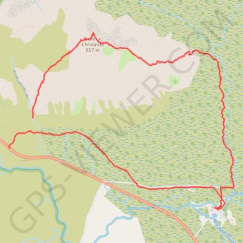
- Distance: 8.6 Km
- Elevation gain: 585 m
- Maximum elevation: 853 m
- Elevation loss: 656 m
- Minimum elevation: 240 m
- Moving time: 2 h 47 m
- Moving speed: 3.1 Km/h
- Maximum speed: 5.9 Km/h
- Total time: 6 h 13 m
- Global speed: 1.4 Km/h
Interactive trail map
Trail profile
- Distance: 8.6 Km
- Elevation gain: 585 m
- Maximum elevation: 853 m
- Elevation loss: 656 m
- Minimum elevation: 240 m
- Moving time: 2 h 47 m
- Moving speed: 3.1 Km/h
- Maximum speed: 5.9 Km/h
- Total time: 6 h 13 m
- Global speed: 1.4 Km/h
About this trail
Name: Pink Rib and descent from Beinn a Chrulaiste trail, distance, elevation, map, profile, GPS track
Start: Old Military Road, Highland, Scotland, PH49 4HY, United Kingdom (56.66048 -4.87448)
End: A82, Highland, Scotland, PH49 4HY, United Kingdom (56.65746 -4.87866)
Coordinates: 56.65130 -4.87881 56.66900 -4.83772
Other hiking, mountain biking, running and outdoor activity trails
Click on a trail to view its statistics, map and profile.