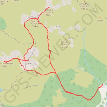
Munro Hillwalk Sgurr na h-Ulaidh Beinn Fhionnlaidh
- Distance: 21.1 Km
- Elevation gain: 1,725 m
- Maximum elevation: 982 m
- Elevation loss: 1,724 m
- Minimum elevation: 44 m
- Moving time: 7 h 14 m
- Moving speed: 2.9 Km/h
- Maximum speed: 32.7 Km/h
- Total time: 9 h 5 m
- Global speed: 2.3 Km/h
Interactive trail map
Trail profile
- Distance: 21.1 Km
- Elevation gain: 1,725 m
- Maximum elevation: 982 m
- Elevation loss: 1,724 m
- Minimum elevation: 44 m
- Moving time: 7 h 14 m
- Moving speed: 2.9 Km/h
- Maximum speed: 32.7 Km/h
- Total time: 9 h 5 m
- Global speed: 2.3 Km/h
About this trail
Name: Munro Hillwalk Sgurr na h-Ulaidh Beinn Fhionnlaidh trail, distance, elevation, map, profile, GPS track
Start: Glen Etive Road, Invercharnan, Highland, Scotland, PH49 4JA, United Kingdom (56.59116 -5.02571)
End: Glen Etive Road, Invercharnan, Highland, Scotland, PH49 4JA, United Kingdom (56.59124 -5.02569)
Coordinates: 56.58378 -5.10497 56.62493 -5.02566
Other hiking, mountain biking, running and outdoor activity trails
Click on a trail to view its statistics, map and profile.