Make a donation
Gear up for your next adventure:
As an Amazon Associate, this site earns from qualifying purchases at no extra cost to you.
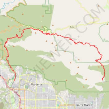
Gabrielino Trail
Starting from Chantry Flat, the Gabrielino Trail slips from the shaded ridge above Big Santa Anita Canyon into a classic Angeles National Forest corridor of wooded slopes, creekside cabins and canyon-bottom shade. The route passes the lower canyon junctions, Cascade Picnic Area and Spruce Grove Trail Camp before leaving the busier approach behind and climbing toward the more open, remote terrain around Newcomb Pass.
Beyond the pass, the trail drops into a wilder section of the San Gabriel Mountains, reaching Devore Trail Camp and then following the West Fork of the San Gabriel River through repeated stream crossings, riparian pockets and quiet backcountry camps. West Fork Trail Camp, the Valley Forge area and the gradual approach to Red Box mark the transition from enclosed canyon travel to broader mountain views and the headwaters leading into the Arroyo Seco side of the route.
From Red Box, the Gabrielino Trail descends toward Switzer Picnic Area, then continues past the historic Switzer-Land ruins and exposed views into Bear Canyon before returning to the Arroyo Seco near Oakwilde. The final stretch follows the canyon past Paul Little, Niño and Gould Mesa, then eases toward the urban edge beside JPL and finishes at the Windsor Avenue trailhead near Altadena.
#Hiking #Mountain #Nature #River #Forest #Angeles #Canyon #Creek
- Distance: 44.4 Km
- Elevation gain: 2,358 m
- Maximum elevation: 1,421 m
- Elevation loss: 2,659 m
- Minimum elevation: 350 m
Interactive trail map
Make a donation
Gear up for your next adventure:
As an Amazon Associate, this site earns from qualifying purchases at no extra cost to you.
Trail profile
- Distance: 44.4 Km
- Elevation gain: 2,358 m
- Maximum elevation: 1,421 m
- Elevation loss: 2,659 m
- Minimum elevation: 350 m
Make a donation
Gear up for your next adventure:
As an Amazon Associate, this site earns from qualifying purchases at no extra cost to you.
About this trail
Name: Gabrielino Trail trail, distance, elevation, map, profile, GPS track
Coordinates: 34.19402 -118.18430 34.26689 -118.01773
Make a donation
Gear up for your next adventure:
As an Amazon Associate, this site earns from qualifying purchases at no extra cost to you.
Other hiking, mountain biking, running and outdoor activity trails
Click on a trail to view its statistics, map and profile.
Switzer Falls
United States > California > Los Angeles County
Starting at Switzer Picnic Site in Angeles National Forest, this hike follows the Gabrielino Trail into the shaded Arroyo Seco canyon, leaving the picnic area and bridge behind as the stream becomes the main companion of the route. The path continues through wooded bends, creek crossings, canyon walls, and…
Distance: 2.9 Km • Elevation gain: 71 m • Maximum elevation: 1,006 m
Switzer Falls via Gabrielino Trail and Bear Canyon Trail in Angeles National Forest
United States > California > Los Angeles County
The hike to Switzer Falls via the Gabrielino and Bear Canyon Trails in Angeles National Forest offers a rich tapestry of natural and historical features. Hikers traverse shaded paths alongside the Arroyo Seco stream, pass by historic ruins of the Switzer Trail Camp, and encounter the picturesque Switzer Falls,…
Distance: 6.1 Km • Elevation gain: 243 m • Maximum elevation: 1,007 m
Strawberry Peak Trail in Angeles National Forest
United States > California > Los Angeles County
The Strawberry Peak Trail in Angeles National Forest offers hikers a challenging yet rewarding journey through diverse terrains. Starting from the Red Box Picnic Area, the path meanders through shaded canyons, ascends exposed ridges and rocky outcrops, culminating at the peak's distinctive, strawberry-shaped…
Distance: 11.6 Km • Elevation gain: 928 m • Maximum elevation: 1,863 m
Bear Canyon Trail Camp via Gabrielino Trail and Bear Canyon Trail
United States > California > Los Angeles County
The Bear Canyon Trail Camp route offers a rewarding adventure through the scenic Angeles National Forest. Along the path, hikers can enjoy the calming sounds of water while crossing the Arroyo Seco, pass by the lush, shaded areas of Bear Creek, and take in views of Switzer Falls from various vantage points.…
Distance: 5.3 Km • Elevation gain: 227 m • Maximum elevation: 1,014 m
Make a donation
Gear up for your next adventure:
As an Amazon Associate, this site earns from qualifying purchases at no extra cost to you.
Dawn Mine Loop via Sunset Ridge Trail in Angeles National Forest
United States > California > Los Angeles County > Altadena
The Dawn Mine Loop Trail in the Angeles National Forest offers hikers a diverse and rewarding experience. The journey begins with a shaded ascent through Millard Canyon, where the lush vegetation and occasional stream crossings provide a refreshing start. As you approach the historic Dawn Mine, the trail…
Distance: 8.7 Km • Elevation gain: 606 m • Maximum elevation: 1,096 m
Eaton Canyon Trail to waterfall in Angeles National Forest
United States > California > Los Angeles County > Pasadena
The Eaton Canyon Trail offers hikers a scenic journey through a diverse landscape in the San Gabriel Mountains, beginning with a wide, dusty path that gradually transitions into a lush canyon environment. Along the way, hikers will cross gentle streams and observe a variety of flora, including oak trees and…
Distance: 2.6 Km • Elevation gain: 130 m • Maximum elevation: 453 m
Mount Wilson Trail in Angeles National Forest
United States > California > Los Angeles County > Sierra Madre
The Mount Wilson Trail in the Angeles National Forest offers hikers a challenging ascent through diverse ecosystems, including shaded woodlands and rugged canyons. Along the route, one can observe the historic ruins of Orchard Camp, a popular resort from the 1890s to the 1930s. Upon reaching the summit, hikers…
Distance: 23.0 Km • Elevation gain: 1,829 m • Maximum elevation: 1,726 m
Eaton Canyon Waterfall via Eaton Canyon Trail
United States > California > Los Angeles County > Pasadena
The Eaton Canyon Waterfall hike offers an easy-to-moderate adventure with plenty of scenic variety, from open canyon views to cool creek crossings. The path winds through trees and rocky stream beds, leading to a refreshing waterfall perfect for a quick rest. It’s a delightful, family-friendly hike that…
Distance: 6.7 Km • Elevation gain: 228 m • Maximum elevation: 459 m
Make a donation
Gear up for your next adventure:
As an Amazon Associate, this site earns from qualifying purchases at no extra cost to you.
Echo Mountain via Lower Sam Merrill Trail
United States > California > Los Angeles County > Altadena
The hike to Echo Mountain via the Lower Sam Merrill Trail offers a blend of history, nature, and panoramic views of the Los Angeles area. As you ascend, you'll pass remnants of the old Mt. Lowe Railway, including the ruins of the Echo Mountain House, which was once a luxurious resort accessible only by incline…
Distance: 9.1 Km • Elevation gain: 752 m • Maximum elevation: 972 m
Make a donation
Gear up for your next adventure:
As an Amazon Associate, this site earns from qualifying purchases at no extra cost to you.
Make a donation
Gear up for your next adventure:
As an Amazon Associate, this site earns from qualifying purchases at no extra cost to you.
Make a donation
Gear up for your next adventure:
As an Amazon Associate, this site earns from qualifying purchases at no extra cost to you.
Make a donation
Gear up for your next adventure:
As an Amazon Associate, this site earns from qualifying purchases at no extra cost to you.
Dawn Mine, Millard Creek and Millard Falls
United States > California > Los Angeles County
Distance: 4.1 Km • Elevation gain: 87 m • Maximum elevation: 930 m
Occidental Peak Trail
United States > California > Los Angeles County > Mount Wilson
Distance: 3.3 Km • Elevation gain: 159 m • Maximum elevation: 1,709 m