Make a donation
Gear up for your next adventure:
As an Amazon Associate, this site earns from qualifying purchases at no extra cost to you.
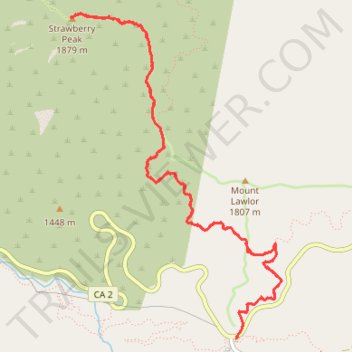
Strawberry Peak Trail in Angeles National Forest
The Strawberry Peak Trail in Angeles National Forest offers hikers a challenging yet rewarding journey through diverse terrains. Starting from the Red Box Picnic Area, the path meanders through shaded canyons, ascends exposed ridges and rocky outcrops, culminating at the peak's distinctive, strawberry-shaped summit. Along the way, hikers can enjoy views of the San Gabriel Mountains, the Los Angeles Basin, and, on clear days, the distant Pacific Ocean. The varied landscape, from dense forests to open ridges, ensures a dynamic and visually stimulating hiking experience. #Hiking #Mountain #Forest #Nature #Overlook
- Distance: 11.6 Km
- Elevation gain: 928 m
- Maximum elevation: 1,863 m
- Elevation loss: 929 m
- Minimum elevation: 1,415 m
- Moving time: 3 h 20 m
- Moving speed: 3.5 Km/h
- Maximum speed: 6.5 Km/h
- Total time: 3 h 51 m
- Global speed: 3.0 Km/h
Interactive trail map
Make a donation
Gear up for your next adventure:
As an Amazon Associate, this site earns from qualifying purchases at no extra cost to you.
Trail profile
- Distance: 11.6 Km
- Elevation gain: 928 m
- Maximum elevation: 1,863 m
- Elevation loss: 929 m
- Minimum elevation: 1,415 m
- Moving time: 3 h 20 m
- Moving speed: 3.5 Km/h
- Maximum speed: 6.5 Km/h
- Total time: 3 h 51 m
- Global speed: 3.0 Km/h
Make a donation
Gear up for your next adventure:
As an Amazon Associate, this site earns from qualifying purchases at no extra cost to you.
About this trail
Name: Strawberry Peak Trail in Angeles National Forest trail, distance, elevation, map, profile, GPS track
Coordinates: 34.25828 -118.12045 34.28382 -118.10036
Make a donation
Gear up for your next adventure:
As an Amazon Associate, this site earns from qualifying purchases at no extra cost to you.
Other hiking, mountain biking, running and outdoor activity trails
Click on a trail to view its statistics, map and profile.
Gabrielino Trail
United States > California > Los Angeles County
Starting from Chantry Flat, the Gabrielino Trail slips from the shaded ridge above Big Santa Anita Canyon into a classic Angeles National Forest corridor of wooded slopes, creekside cabins and canyon-bottom shade. The route passes the lower canyon junctions, Cascade Picnic Area and Spruce Grove Trail Camp…
Distance: 44.4 Km • Elevation gain: 2,358 m • Maximum elevation: 1,421 m
Make a donation
Gear up for your next adventure:
As an Amazon Associate, this site earns from qualifying purchases at no extra cost to you.