Make a donation
Gear up for your next adventure:
As an Amazon Associate, this site earns from qualifying purchases at no extra cost to you.
Switzer Falls
Hike to Switzer Falls via Gabrielino Trail and Bear Canyon Trail in Angeles National Forest #Hiking #Waterfall #Forest #River #Mountain
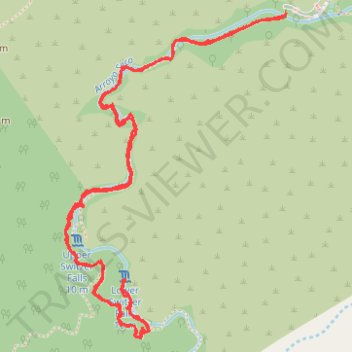
- Distance: 6.2 Km
- Elevation gain: 243 m
- Maximum elevation: 1,006 m
- Elevation loss: 243 m
- Minimum elevation: 862 m
- Moving time: 2 h 12 m
- Moving speed: 2.8 Km/h
- Maximum speed: 6.9 Km/h
- Total time: 3 h 25 m
- Global speed: 1.8 Km/h
Interactive trail map
Make a donation
Gear up for your next adventure:
As an Amazon Associate, this site earns from qualifying purchases at no extra cost to you.
Trail profile
- Distance: 6.2 Km
- Elevation gain: 243 m
- Maximum elevation: 1,006 m
- Elevation loss: 243 m
- Minimum elevation: 862 m
- Moving time: 2 h 12 m
- Moving speed: 2.8 Km/h
- Maximum speed: 6.9 Km/h
- Total time: 3 h 25 m
- Global speed: 1.8 Km/h
Make a donation
Gear up for your next adventure:
As an Amazon Associate, this site earns from qualifying purchases at no extra cost to you.
About this trail
Name: Switzer Falls trail, distance, elevation, map, profile, GPS track
Start: Gabrielino Trail, Los Angeles County, California, United States (34.26615 -118.14567)
End: Gabrielino Trail, Los Angeles County, California, United States (34.26616 -118.14567)
Coordinates: 34.25429 -118.15543 34.26616 -118.14567
Make a donation
Gear up for your next adventure:
As an Amazon Associate, this site earns from qualifying purchases at no extra cost to you.
Other hiking, mountain biking, running and outdoor activity trails
Click on a trail to view its statistics, map and profile.
Gabrielino Trail
United States > California > Los Angeles County
Starting from Chantry Flat, the Gabrielino Trail slips from the shaded ridge above Big Santa Anita Canyon into a classic Angeles National Forest corridor of wooded slopes, creekside cabins and canyon-bottom shade. The route passes the lower canyon junctions, Cascade Picnic Area and Spruce Grove Trail Camp…
Distance: 44.4 Km • Elevation gain: 2,358 m • Maximum elevation: 1,421 m
Switzer Falls
United States > California > Los Angeles County
Starting at Switzer Picnic Site in Angeles National Forest, this hike follows the Gabrielino Trail into the shaded Arroyo Seco canyon, leaving the picnic area and bridge behind as the stream becomes the main companion of the route. The path continues through wooded bends, creek crossings, canyon walls, and…
Distance: 2.9 Km • Elevation gain: 71 m • Maximum elevation: 1,006 m
Switzer Falls via Gabrielino Trail and Bear Canyon Trail in Angeles National Forest
United States > California > Los Angeles County
The hike to Switzer Falls via the Gabrielino and Bear Canyon Trails in Angeles National Forest offers a rich tapestry of natural and historical features. Hikers traverse shaded paths alongside the Arroyo Seco stream, pass by historic ruins of the Switzer Trail Camp, and encounter the picturesque Switzer Falls,…
Distance: 6.1 Km • Elevation gain: 243 m • Maximum elevation: 1,007 m
Bear Canyon Trail Camp via Gabrielino Trail and Bear Canyon Trail
United States > California > Los Angeles County
The Bear Canyon Trail Camp route offers a rewarding adventure through the scenic Angeles National Forest. Along the path, hikers can enjoy the calming sounds of water while crossing the Arroyo Seco, pass by the lush, shaded areas of Bear Creek, and take in views of Switzer Falls from various vantage points.…
Distance: 5.3 Km • Elevation gain: 227 m • Maximum elevation: 1,014 m
Make a donation
Gear up for your next adventure:
As an Amazon Associate, this site earns from qualifying purchases at no extra cost to you.