Make a donation
Gear up for your next adventure:
As an Amazon Associate, this site earns from qualifying purchases at no extra cost to you.
Eaton Canyon Waterfall
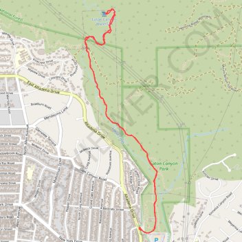
Interactive trail map
Make a donation
Gear up for your next adventure:
As an Amazon Associate, this site earns from qualifying purchases at no extra cost to you.
Trail profile
- Distance: 6.9 Km
- Elevation gain: 254 m
- Maximum elevation: 452 m
- Elevation loss: 254 m
- Minimum elevation: 291 m
Make a donation
Gear up for your next adventure:
As an Amazon Associate, this site earns from qualifying purchases at no extra cost to you.
About this trail
Name: Eaton Canyon Waterfall trail, distance, elevation, map, profile, GPS track
Coordinates: 34.17580 -118.10460 34.19703 -118.09631
Make a donation
Gear up for your next adventure:
As an Amazon Associate, this site earns from qualifying purchases at no extra cost to you.
Other hiking, mountain biking, running and outdoor activity trails
Click on a trail to view its statistics, map and profile.
Gabrielino Trail
United States > California > Los Angeles County
Starting from Chantry Flat, the Gabrielino Trail slips from the shaded ridge above Big Santa Anita Canyon into a classic Angeles National Forest corridor of wooded slopes, creekside cabins and canyon-bottom shade. The route passes the lower canyon junctions, Cascade Picnic Area and Spruce Grove Trail Camp…
Distance: 44.4 Km • Elevation gain: 2,358 m • Maximum elevation: 1,421 m
Eaton Canyon Trail to waterfall in Angeles National Forest
United States > California > Los Angeles County > Pasadena
The Eaton Canyon Trail offers hikers a scenic journey through a diverse landscape in the San Gabriel Mountains, beginning with a wide, dusty path that gradually transitions into a lush canyon environment. Along the way, hikers will cross gentle streams and observe a variety of flora, including oak trees and…
Distance: 2.6 Km • Elevation gain: 130 m • Maximum elevation: 453 m
Eaton Canyon Waterfall via Eaton Canyon Trail
United States > California > Los Angeles County > Pasadena
The Eaton Canyon Waterfall hike offers an easy-to-moderate adventure with plenty of scenic variety, from open canyon views to cool creek crossings. The path winds through trees and rocky stream beds, leading to a refreshing waterfall perfect for a quick rest. It’s a delightful, family-friendly hike that…
Distance: 6.7 Km • Elevation gain: 228 m • Maximum elevation: 459 m
Make a donation
Gear up for your next adventure:
As an Amazon Associate, this site earns from qualifying purchases at no extra cost to you.