Thank you for supporting this site ❤️
Make a donation
Make a donation
Gear up for your next adventure:
As an Amazon Associate, this site earns from qualifying purchases at no extra cost to you.
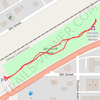
Steelhead Park
- Distance: 0.6 Km
- Elevation gain: 2 m
- Maximum elevation: 596 m
- Elevation loss: 2 m
- Minimum elevation: 594 m
- Moving time: 7 m 30 s
- Moving speed: 4.8 Km/h
- Maximum speed: 6.4 Km/h
- Total time: 9 m 58 s
- Global speed: 3.6 Km/h
Interactive trail map
Thank you for supporting this site ❤️
Make a donation
Make a donation
Gear up for your next adventure:
As an Amazon Associate, this site earns from qualifying purchases at no extra cost to you.
Trail profile
- Distance: 0.6 Km
- Elevation gain: 2 m
- Maximum elevation: 596 m
- Elevation loss: 2 m
- Minimum elevation: 594 m
- Moving time: 7 m 30 s
- Moving speed: 4.8 Km/h
- Maximum speed: 6.4 Km/h
- Total time: 9 m 58 s
- Global speed: 3.6 Km/h
Thank you for supporting this site ❤️
Make a donation
Make a donation
Gear up for your next adventure:
As an Amazon Associate, this site earns from qualifying purchases at no extra cost to you.
About this trail
Name: Steelhead Park trail, distance, elevation, map, profile, GPS track
Coordinates: 54.40021 -126.64931 54.40158 -126.64578
Topography: Regional District of Bulkley-Nechako topographic map, elevation, terrain
Thank you for supporting this site ❤️
Make a donation
Make a donation
Gear up for your next adventure:
As an Amazon Associate, this site earns from qualifying purchases at no extra cost to you.
Other hiking, mountain biking, running and outdoor activity trails
Click on a trail to view its statistics, map and profile.