Make a donation
Gear up for your next adventure:
As an Amazon Associate, this site earns from qualifying purchases at no extra cost to you.
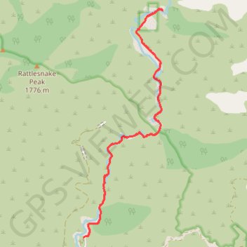
Bridge to Nowhere
- Distance: 15.4 Km
- Elevation gain: 563 m
- Maximum elevation: 864 m
- Elevation loss: 563 m
- Minimum elevation: 611 m
Interactive trail map
Make a donation
Gear up for your next adventure:
As an Amazon Associate, this site earns from qualifying purchases at no extra cost to you.
Trail profile
- Distance: 15.4 Km
- Elevation gain: 563 m
- Maximum elevation: 864 m
- Elevation loss: 563 m
- Minimum elevation: 611 m
Make a donation
Gear up for your next adventure:
As an Amazon Associate, this site earns from qualifying purchases at no extra cost to you.
About this trail
Name: Bridge to Nowhere trail, distance, elevation, map, profile, GPS track
Start: Camp Bonita Road, Los Angeles County, California, United States (34.23696 -117.76546)
End: Camp Bonita Road, Los Angeles County, California, United States (34.23696 -117.76546)
Coordinates: 34.23696 -117.76546 34.28335 -117.74597
Make a donation
Gear up for your next adventure:
As an Amazon Associate, this site earns from qualifying purchases at no extra cost to you.
Other hiking, mountain biking, running and outdoor activity trails
Click on a trail to view its statistics, map and profile.
Bridge to Nowhere
United States > California > Los Angeles County
From Bridge to Nowhere Trailhead near Coyote Flat, the route enters Sheep Mountain Wilderness on the East Fork Trail and follows the East Fork of the San Gabriel River into a steep San Gabriel Mountains canyon of chaparral slopes, gravel bars and bouldery riverbank. The path continues upstream along the rocky…
Distance: 15.3 Km • Elevation gain: 544 m • Maximum elevation: 864 m
Return from Bridge to Nowhere
United States > California > Los Angeles County
Distance: 7.8 Km • Elevation gain: 222 m • Maximum elevation: 875 m