Crystal Cove State Park
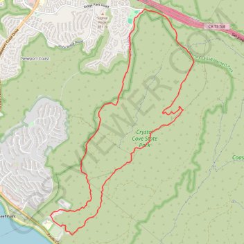
Crystal Cove State Park’s loop starts near the El Moro coastal entrance, crosses into Moro Canyon, and follows a sheltered inland corridor shaped by seasonal Moro Creek, riparian woodland, coastal sage scrub, and the rugged slopes of the San Joaquin Hills.
The hike then climbs toward the higher backcountry and Pacific Ridge area, where open ridgelines offer sweeping views over Crystal Cove’s canyon system, the mountainous interior of the park, and the blue Pacific Ocean.
The return follows an exposed ridge above Muddy Canyon before descending toward the coastal side of El Moro, completing a varied circuit through canyon solitude, broad hilltop scenery, and the protected coastal landscape of Crystal Cove State Park.
#Hiking #Loop #Nature #Forest #Park #Mountain #Sea #Pacific #Ocean #Canyon
- Distance: 14.4 Km
- Elevation gain: 397 m
- Maximum elevation: 314 m
- Elevation loss: 396 m
- Minimum elevation: 14 m
Interactive trail map
Trail profile
- Distance: 14.4 Km
- Elevation gain: 397 m
- Maximum elevation: 314 m
- Elevation loss: 396 m
- Minimum elevation: 14 m
About this trail
Name: Crystal Cove State Park trail, distance, elevation, map, profile, GPS track
Coordinates: 33.56221 -117.82331 33.60581 -117.78998
Other hiking, mountain biking, running and outdoor activity trails
Click on a trail to view its statistics, map and profile.
El Moro Canyon Loop Trail in Crystal Cove State Park
United States > California > Orange County
The El Moro Canyon Loop Trail in Crystal Cove State Park offers a rewarding journey through diverse terrains, including canyons, rolling hills and ridgelines. Along the path, hikers will encounter expansive vistas of the Pacific Ocean, with views extending to Newport Beach to the north and Laguna Beach to the…
Distance: 8.0 Km • Elevation gain: 248 m • Maximum elevation: 222 m