Make a donation
Gear up for your next adventure:
As an Amazon Associate, this site earns from qualifying purchases at no extra cost to you.
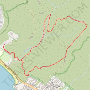
El Moro Canyon Loop Trail in Crystal Cove State Park
The El Moro Canyon Loop Trail in Crystal Cove State Park offers a rewarding journey through diverse terrains, including canyons, rolling hills and ridgelines. Along the path, hikers will encounter expansive vistas of the Pacific Ocean, with views extending to Newport Beach to the north and Laguna Beach to the south. The trail also features sections adorned with vibrant wildflowers, especially during spring, enhancing the natural beauty of the landscape. #Hiking #Loop #Canyon #Nature #Pacific #Ocean #Sea #Coast
- Distance: 8.0 Km
- Elevation gain: 248 m
- Maximum elevation: 222 m
- Elevation loss: 248 m
- Minimum elevation: 14 m
- Moving time: 1 h 49 m
- Moving speed: 4.4 Km/h
- Maximum speed: 13.9 Km/h
- Total time: 1 h 59 m
- Global speed: 4.0 Km/h
Interactive trail map
Make a donation
Gear up for your next adventure:
As an Amazon Associate, this site earns from qualifying purchases at no extra cost to you.
Trail profile
- Distance: 8.0 Km
- Elevation gain: 248 m
- Maximum elevation: 222 m
- Elevation loss: 248 m
- Minimum elevation: 14 m
- Moving time: 1 h 49 m
- Moving speed: 4.4 Km/h
- Maximum speed: 13.9 Km/h
- Total time: 1 h 59 m
- Global speed: 4.0 Km/h
Make a donation
Gear up for your next adventure:
As an Amazon Associate, this site earns from qualifying purchases at no extra cost to you.
About this trail
Name: El Moro Canyon Loop Trail in Crystal Cove State Park trail, distance, elevation, map, profile, GPS track
Start: No Dogs, Orange County, California, 92667, United States (33.56620 -117.82245)
End: No Dogs, Orange County, California, 92667, United States (33.56619 -117.82246)
Coordinates: 33.55870 -117.82287 33.57318 -117.79925
Make a donation
Gear up for your next adventure:
As an Amazon Associate, this site earns from qualifying purchases at no extra cost to you.
Other hiking, mountain biking, running and outdoor activity trails
Click on a trail to view its statistics, map and profile.
Crystal Cove State Park
United States > California > Orange County > Newport Beach
Crystal Cove State Park’s loop starts near the El Moro coastal entrance, crosses into Moro Canyon, and follows a sheltered inland corridor shaped by seasonal Moro Creek, riparian woodland, coastal sage scrub, and the rugged slopes of the San Joaquin Hills. The hike then climbs toward the higher backcountry…
Distance: 14.4 Km • Elevation gain: 397 m • Maximum elevation: 314 m
Make a donation
Gear up for your next adventure:
As an Amazon Associate, this site earns from qualifying purchases at no extra cost to you.