Make a donation
Gear up for your next adventure:
As an Amazon Associate, this site earns from qualifying purchases at no extra cost to you.
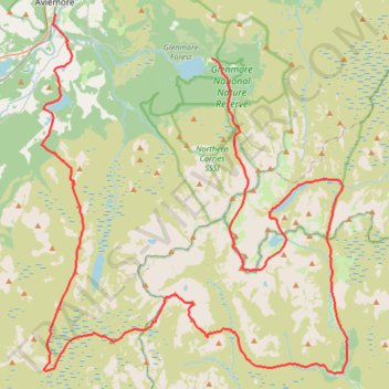
Cairngorms hike
- Distance: 80.8 Km
- Elevation gain: 3,001 m
- Maximum elevation: 1,312 m
- Elevation loss: 2,880 m
- Minimum elevation: 207 m
- Moving time: 19 h 3 m
- Moving speed: 4.2 Km/h
- Maximum speed: 8.9 Km/h
- Total time: 3 d 45 m
- Global speed: 1.1 Km/h
Interactive trail map
Make a donation
Gear up for your next adventure:
As an Amazon Associate, this site earns from qualifying purchases at no extra cost to you.
Trail profile
- Distance: 80.8 Km
- Elevation gain: 3,001 m
- Maximum elevation: 1,312 m
- Elevation loss: 2,880 m
- Minimum elevation: 207 m
- Moving time: 19 h 3 m
- Moving speed: 4.2 Km/h
- Maximum speed: 8.9 Km/h
- Total time: 3 d 45 m
- Global speed: 1.1 Km/h
Make a donation
Gear up for your next adventure:
As an Amazon Associate, this site earns from qualifying purchases at no extra cost to you.
About this trail
Name: Cairngorms hike trail, distance, elevation, map, profile, GPS track
Start: Aviemore, B9152, Aviemore, Highland, Scotland, PH22 1PD, United Kingdom (57.18787 -3.82863)
End: Cairngorm Road, Glenmore, Highland, Scotland, PH22 1QY, United Kingdom (57.16747 -3.69453)
Coordinates: 57.02092 -3.84058 57.18787 -3.57819
Make a donation
Gear up for your next adventure:
As an Amazon Associate, this site earns from qualifying purchases at no extra cost to you.
Other hiking, mountain biking, running and outdoor activity trails
Click on a trail to view its statistics, map and profile.
Munro hillwalk Sgor Gaoith Mullach Clach a' Bhlair
United Kingdom > Scotland > Highland
Distance: 30.1 Km • Elevation gain: 1,157 m • Maximum elevation: 1,108 m
Aviemore to Loch Garten: A Tale of Trails and Trials
United Kingdom > Scotland > Highland > Aviemore
Distance: 35.4 Km • Elevation gain: 261 m • Maximum elevation: 244 m
Munro hillwalk Cairngorm and northern corries
United Kingdom > Scotland > Highland
Distance: 14.6 Km • Elevation gain: 912 m • Maximum elevation: 1,244 m
Glenmore - Meall a' Bhuachaille - Ryvoan Bothy
United Kingdom > Scotland > Highland > Glenmore
Distance: 8.8 Km • Elevation gain: 564 m • Maximum elevation: 807 m
Make a donation
Gear up for your next adventure:
As an Amazon Associate, this site earns from qualifying purchases at no extra cost to you.
Munro hillwalk Mheadhoin Etchachan
United Kingdom > Scotland > Aberdeenshire
Munro, hillwalk, Mheadhoin, Etchachan
Distance: 29.4 Km • Elevation gain: 1,555 m • Maximum elevation: 1,234 m
Munro hillwalk Chaorainn Bhreac
United Kingdom > Scotland > Aberdeenshire
Munro, hillwalk, Chaorainn, Bhreac
Distance: 20.9 Km • Elevation gain: 625 m • Maximum elevation: 1,082 m
Hike up Craigellachie from Aviemore
United Kingdom > Scotland > Highland > Aviemore
Distance: 6.1 Km • Elevation gain: 287 m • Maximum elevation: 492 m