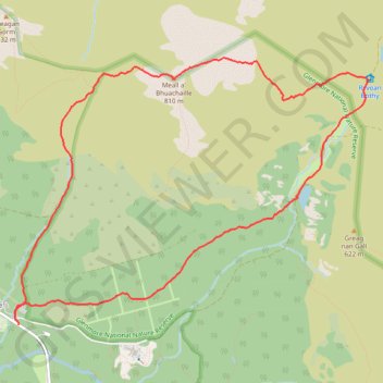
Glenmore - Meall a' Bhuachaille - Ryvoan Bothy
- Distance: 8.8 Km
- Elevation gain: 564 m
- Maximum elevation: 807 m
- Elevation loss: 554 m
- Minimum elevation: 327 m
- Moving time: 2 h 46 m
- Moving speed: 3.2 Km/h
- Maximum speed: 6.8 Km/h
- Total time: 3 h 47 m
- Global speed: 2.3 Km/h
Interactive trail map
Trail profile
- Distance: 8.8 Km
- Elevation gain: 564 m
- Maximum elevation: 807 m
- Elevation loss: 554 m
- Minimum elevation: 327 m
- Moving time: 2 h 46 m
- Moving speed: 3.2 Km/h
- Maximum speed: 6.8 Km/h
- Total time: 3 h 47 m
- Global speed: 2.3 Km/h
About this trail
Name: Glenmore - Meall a' Bhuachaille - Ryvoan Bothy trail, distance, elevation, map, profile, GPS track
Start: Cairngorm Road, Glenmore, Highland, Scotland, PH22 1QU, United Kingdom (57.16633 -3.69112)
Coordinates: 57.16633 -3.69169 57.18503 -3.64598
Other hiking, mountain biking, running and outdoor activity trails
Click on a trail to view its statistics, map and profile.
Aviemore to Loch Garten: A Tale of Trails and Trials
United Kingdom > Scotland > Highland > Aviemore
Distance: 35.4 Km • Elevation gain: 261 m • Maximum elevation: 244 m
Cairngorms hike
United Kingdom > Scotland > Highland > Aviemore
Distance: 80.8 Km • Elevation gain: 3,001 m • Maximum elevation: 1,312 m