Hillwalk Snowdon Crib Goch
- Distance: 15.6 Km
- Elevation gain: 1,047 m
- Maximum elevation: 1,061 m
- Elevation loss: 1,047 m
- Minimum elevation: 360 m
- Moving time: 4 h 47 m
- Moving speed: 3.3 Km/h
- Maximum speed: 12.0 Km/h
- Total time: 5 h 31 m
- Global speed: 2.8 Km/h
Interactive trail map
Trail profile
- Distance: 15.6 Km
- Elevation gain: 1,047 m
- Maximum elevation: 1,061 m
- Elevation loss: 1,047 m
- Minimum elevation: 360 m
- Moving time: 4 h 47 m
- Moving speed: 3.3 Km/h
- Maximum speed: 12.0 Km/h
- Total time: 5 h 31 m
- Global speed: 2.8 Km/h
About this trail
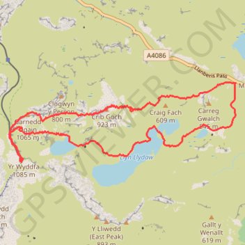
Name: Hillwalk Snowdon Crib Goch trail, distance, elevation, map, profile, GPS track
Start: Pen y Pass, Llanberis Pass, Llanberis, Gwynedd, Wales, LL55 4NU, United Kingdom (53.08042 -4.02093)
End: Pen-y-Pass, Llanberis Pass, Llanberis, Gwynedd, Wales, LL55 4NY, United Kingdom (53.08052 -4.02070)
Coordinates: 53.06797 -4.07992 53.08057 -4.02070
Other hiking, mountain biking, running and outdoor activity trails
Click on a trail to view its statistics, map and profile.
Ultra-Trail Snowdonia Eryri UTS 100M
United Kingdom > Wales > Gwynedd > Llanberis
Distance: 163.3 Km • Elevation gain: 9,704 m • Maximum elevation: 1,058 m