Make a donation
Gear up for your next adventure:
As an Amazon Associate, this site earns from qualifying purchases at no extra cost to you.
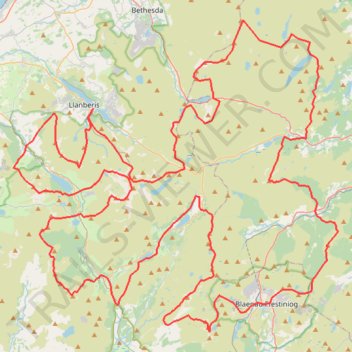
Ultra-Trail Snowdonia Eryri UTS 100M
- Distance: 163.3 Km
- Elevation gain: 9,704 m
- Maximum elevation: 1,058 m
- Elevation loss: 9,703 m
- Minimum elevation: 23 m
Interactive trail map
Make a donation
Gear up for your next adventure:
As an Amazon Associate, this site earns from qualifying purchases at no extra cost to you.
Trail profile
- Distance: 163.3 Km
- Elevation gain: 9,704 m
- Maximum elevation: 1,058 m
- Elevation loss: 9,703 m
- Minimum elevation: 23 m
Make a donation
Gear up for your next adventure:
As an Amazon Associate, this site earns from qualifying purchases at no extra cost to you.
About this trail
Name: Ultra-Trail Snowdonia Eryri UTS 100M trail, distance, elevation, map, profile, GPS track
End: A4086, Llanberis, Gwynedd, Wales, LL55 4UR, United Kingdom (53.11872 -4.11791)
Coordinates: 52.97746 -4.20186 53.17460 -3.85999
Make a donation
Gear up for your next adventure:
As an Amazon Associate, this site earns from qualifying purchases at no extra cost to you.
Other hiking, mountain biking, running and outdoor activity trails
Click on a trail to view its statistics, map and profile.
Braich dinas to craig cwm silyn to obelisk and above knife edge, down above slate mineu
United Kingdom > Wales > Gwynedd
Early section along stream is fun, possibly stay higher to limit exposure. To waterfall would make good walk for kids. Some evidence of path, especially above gorge, but mostly make your own way. One wall to climb, but fairly easy , stay on left-hand side above stream until footbridge and gate Beyond gate I…
Distance: 11.3 Km • Elevation gain: 879 m • Maximum elevation: 729 m
Nantgwynant, Gwynedd - Red Dragon, White Dragon
United Kingdom > Wales > Gwynedd > Beddgelert
A circular walks with wonderful views on clearly defined paths along rivers, woods and some exposed hillsides. Parts may be boggy and muddy at times with rock sections that can be slippery if wet. There are options to shorten the walk.
Distance: 17.0 Km • Elevation gain: 654 m • Maximum elevation: 325 m
Llyn Ogwyn, Devil's Kitchen and Y Garn circuit
United Kingdom > Wales > Conwy
Distance: 9.2 Km • Elevation gain: 743 m • Maximum elevation: 932 m
Aberglaslyn towards Cae Coch - thwarted due to too much vegetation
United Kingdom > Wales > Gwynedd > Nantmor
Gwynedd Walking
Distance: 7.9 Km • Elevation gain: 388 m • Maximum elevation: 214 m
Make a donation
Gear up for your next adventure:
As an Amazon Associate, this site earns from qualifying purchases at no extra cost to you.
Beddgelert, Llyn Dinas, Blaen Nanmor and Nantmor circuit
United Kingdom > Wales > Gwynedd > Beddgelert
Distance: 15.2 Km • Elevation gain: 393 m • Maximum elevation: 182 m
Hillwalk Tryfan Glyder Fach Fawr Garn Elidir Fawr
United Kingdom > Wales > Conwy
Hillwalk, Tryfan, Glyder, Fach, Fawr, Garn, Elidir, Fawr
Distance: 15.3 Km • Elevation gain: 1,357 m • Maximum elevation: 989 m
Hillwalk Carnedd Dafydd LLewelyn Foel-fras
United Kingdom > Wales > Conwy
Distance: 20.9 Km • Elevation gain: 1,261 m • Maximum elevation: 1,060 m
Hillwalk Snowdon Crib Goch
United Kingdom > Wales > Gwynedd
Distance: 15.6 Km • Elevation gain: 1,047 m • Maximum elevation: 1,061 m
Make a donation
Gear up for your next adventure:
As an Amazon Associate, this site earns from qualifying purchases at no extra cost to you.
Walk to Dinas Emrys
United Kingdom > Wales > Gwynedd > Beddgelert
Distance: 3.7 Km • Elevation gain: 142 m • Maximum elevation: 117 m
Conwy Hiking
United Kingdom > Wales > Conwy > Caerhun
Distance: 18.0 Km • Elevation gain: 212 m • Maximum elevation: 969 m
Marchlyn Mawr
United Kingdom > Wales > Gwynedd > Dinorwig
Distance: 3.1 Km • Elevation gain: 293 m • Maximum elevation: 642 m
Bluebell walk at Menter Fachwen
United Kingdom > Wales > Gwynedd > Brynrefail > Fachwen
Walk to look at the Bluebells at Menter Fachwen and found a new permissive path
Distance: 1.7 Km • Elevation gain: 112 m • Maximum elevation: 208 m
Make a donation
Gear up for your next adventure:
As an Amazon Associate, this site earns from qualifying purchases at no extra cost to you.
Hafod Garrerog
United Kingdom > Wales > Gwynedd > Beddgelert
Distance: 2.4 Km • Elevation gain: 55 m • Maximum elevation: 43 m