Make a donation
Gear up for your next adventure:
As an Amazon Associate, this site earns from qualifying purchases at no extra cost to you.
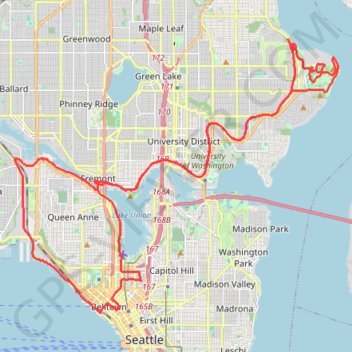
Biking around Seattle
- Distance: 47.6 Km
- Elevation gain: 407 m
- Maximum elevation: 55 m
- Elevation loss: 405 m
- Minimum elevation: -1 m
- Moving time: 3 h 17 m
- Moving speed: 14.5 Km/h
- Maximum speed: 64.9 Km/h
- Total time: 5 h 31 m
- Global speed: 8.6 Km/h
Interactive trail map
Make a donation
Gear up for your next adventure:
As an Amazon Associate, this site earns from qualifying purchases at no extra cost to you.
Trail profile
- Distance: 47.6 Km
- Elevation gain: 407 m
- Maximum elevation: 55 m
- Elevation loss: 405 m
- Minimum elevation: -1 m
- Moving time: 3 h 17 m
- Moving speed: 14.5 Km/h
- Maximum speed: 64.9 Km/h
- Total time: 5 h 31 m
- Global speed: 8.6 Km/h
Make a donation
Gear up for your next adventure:
As an Amazon Associate, this site earns from qualifying purchases at no extra cost to you.
About this trail
Name: Biking around Seattle trail, distance, elevation, map, profile, GPS track
Coordinates: 47.61133 -122.38626 47.69072 -122.24635
Make a donation
Gear up for your next adventure:
As an Amazon Associate, this site earns from qualifying purchases at no extra cost to you.
Other hiking, mountain biking, running and outdoor activity trails
Click on a trail to view its statistics, map and profile.
Trace around west side of University of Washington, near the hospital and lake union
United States > Washington > King County > Seattle
Distance: 3.3 Km • Elevation gain: 59 m • Maximum elevation: 54 m
Maple Leaf & Kingfisher Natural Area Loop
United States > Washington > King County > Seattle
Distance: 4.8 Km • Elevation gain: 111 m • Maximum elevation: 136 m
More biking around Seattle
United States > Washington > King County > Seattle
Distance: 21.2 Km • Elevation gain: 252 m • Maximum elevation: 53 m
Queen Anne Greenbelt trails tracing
United States > Washington > King County > Seattle
West Queen Anne Loop
Distance: 6.9 Km • Elevation gain: 199 m • Maximum elevation: 101 m
Make a donation
Gear up for your next adventure:
As an Amazon Associate, this site earns from qualifying purchases at no extra cost to you.
Washington Park North Arboretum Ramble
United States > Washington > King County > Seattle
Distance: 3.6 Km • Elevation gain: 38 m • Maximum elevation: 29 m
Maple Leaf & Thornton Creek Loop
United States > Washington > King County > Seattle
Distance: 7.7 Km • Elevation gain: 119 m • Maximum elevation: 135 m