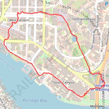
Trace around west side of University of Washington, near the hospital and lake union
- Distance: 3.3 Km
- Elevation gain: 59 m
- Maximum elevation: 54 m
- Elevation loss: 59 m
- Minimum elevation: 5 m
- Moving time: 58 m 27 s
- Moving speed: 3.4 Km/h
- Maximum speed: 3.9 Km/h
- Total time: 59 m 20 s
- Global speed: 3.4 Km/h
Interactive trail map
Trail profile
- Distance: 3.3 Km
- Elevation gain: 59 m
- Maximum elevation: 54 m
- Elevation loss: 59 m
- Minimum elevation: 5 m
- Moving time: 58 m 27 s
- Moving speed: 3.4 Km/h
- Maximum speed: 3.9 Km/h
- Total time: 59 m 20 s
- Global speed: 3.4 Km/h
About this trail
Name: Trace around west side of University of Washington, near the hospital and lake union trail, distance, elevation, map, profile, GPS track
Coordinates: 47.64832 -122.31765 47.65639 -122.30349
Other hiking, mountain biking, running and outdoor activity trails
Click on a trail to view its statistics, map and profile.
Biking around Seattle
United States > Washington > King County > Seattle
Distance: 47.6 Km • Elevation gain: 407 m • Maximum elevation: 55 m