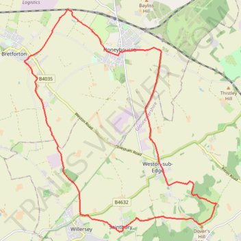
Dover's Hill - Bretforton - Honeybourne - Dover's Hill
- Distance: 19.0 Km
- Elevation gain: 235 m
- Maximum elevation: 224 m
- Elevation loss: 236 m
- Minimum elevation: 39 m
- Moving time: 2 h 2 m
- Moving speed: 9.3 Km/h
- Maximum speed: 16.5 Km/h
- Total time: 2 h 4 m
- Global speed: 9.2 Km/h
Interactive trail map
Trail profile
- Distance: 19.0 Km
- Elevation gain: 235 m
- Maximum elevation: 224 m
- Elevation loss: 236 m
- Minimum elevation: 39 m
- Moving time: 2 h 2 m
- Moving speed: 9.3 Km/h
- Maximum speed: 16.5 Km/h
- Total time: 2 h 4 m
- Global speed: 9.2 Km/h
About this trail
Name: Dover's Hill - Bretforton - Honeybourne - Dover's Hill trail, distance, elevation, map, profile, GPS track
Coordinates: 52.05353 -1.86694 52.10377 -1.79636
Other hiking, mountain biking, running and outdoor activity trails
Click on a trail to view its statistics, map and profile.
Dover's Hill and Broadway Hill loop trailrun
United Kingdom > England > Gloucestershire > Cotswold District
Distance: 22.0 Km • Elevation gain: 569 m • Maximum elevation: 314 m