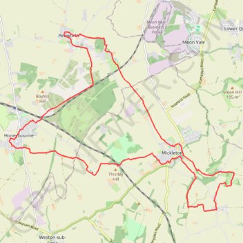
Pebworth Hidcote Honeybourne Trailrun
Loop run / hike /MTB via Pebworth, Mickleton, Hidcote Bartrim, Hidcote Boyce and Honeybourne. #Running #Hiking #MTB #Loop #Countryside #Nature
- Distance: 23.1 Km
- Elevation gain: 245 m
- Maximum elevation: 196 m
- Elevation loss: 244 m
- Minimum elevation: 45 m
- Moving time: 2 h 40 m
- Moving speed: 8.6 Km/h
- Maximum speed: 14.0 Km/h
- Total time: 2 h 41 m
- Global speed: 8.6 Km/h
Interactive trail map
Trail profile
- Distance: 23.1 Km
- Elevation gain: 245 m
- Maximum elevation: 196 m
- Elevation loss: 244 m
- Minimum elevation: 45 m
- Moving time: 2 h 40 m
- Moving speed: 8.6 Km/h
- Maximum speed: 14.0 Km/h
- Total time: 2 h 41 m
- Global speed: 8.6 Km/h
About this trail
Name: Pebworth Hidcote Honeybourne Trailrun trail, distance, elevation, map, profile, GPS track
Coordinates: 52.07553 -1.83588 52.12085 -1.74324
Other hiking, mountain biking, running and outdoor activity trails
Click on a trail to view its statistics, map and profile.
Stratford Greenway + Loop
United Kingdom > England > Warwickshire > Stratford-on-Avon > Stratford-upon-Avon
Distance: 21.7 Km • Elevation gain: 73 m • Maximum elevation: 65 m
Dover's Hill - Bretforton - Honeybourne - Dover's Hill
United Kingdom > England > Gloucestershire > Cotswold District
Distance: 19.0 Km • Elevation gain: 235 m • Maximum elevation: 224 m
Mickleton Hills
United Kingdom > England > Gloucestershire > Cotswold District > Mickleton
Distance: 22.0 Km • Elevation gain: 468 m • Maximum elevation: 262 m
Mickleton Trailrun
United Kingdom > England > Gloucestershire > Cotswold District > Mickleton
Distance: 11.8 Km • Elevation gain: 190 m • Maximum elevation: 199 m