Josephine Peak
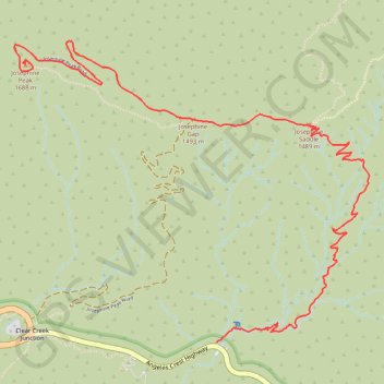
Hike to the Josephine Peak by the Colby Canyon, the Josephine Saddle and the Josephine Gap in the San Gabriel Mountains National Monument and the Angeles National Forest. #Hiking #Mountain #Nature #Canyon #Forest #River #Angeles
- Distance: 6.7 Km
- Elevation gain: 677 m
- Maximum elevation: 1,667 m
- Elevation loss: 85 m
- Minimum elevation: 1,072 m
Interactive trail map
Trail profile
- Distance: 6.7 Km
- Elevation gain: 677 m
- Maximum elevation: 1,667 m
- Elevation loss: 85 m
- Minimum elevation: 1,072 m
About this trail
Name: Josephine Peak trail, distance, elevation, map, profile, GPS track
Start: Angeles Crest Highway, Los Angeles County, California, United States (34.26975 -118.14067)
End: Josephine Peak Summit Trail, Los Angeles County, California, United States (34.28561 -118.15390)
Coordinates: 34.26975 -118.15467 34.28699 -118.13011