Make a donation
Gear up for your next adventure:
As an Amazon Associate, this site earns from qualifying purchases at no extra cost to you.
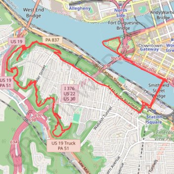
Point State to Emerald View Loop
Loop hike from Point State Park through Emerald View Park via Monongahela River, Smithfield Street Bridge, Grandview Avenue and Emerald View Trail. #Hiking #Loop #Nature #Park #River #Forest #City
- Distance: 19.8 Km
- Elevation gain: 761 m
- Maximum elevation: 352 m
- Elevation loss: 761 m
- Minimum elevation: 212 m
- Moving time: 4 h 2 m
- Moving speed: 4.9 Km/h
- Maximum speed: 23.5 Km/h
- Total time: 4 h 37 m
- Global speed: 4.3 Km/h
Interactive trail map
Make a donation
Gear up for your next adventure:
As an Amazon Associate, this site earns from qualifying purchases at no extra cost to you.
Trail profile
- Distance: 19.8 Km
- Elevation gain: 761 m
- Maximum elevation: 352 m
- Elevation loss: 761 m
- Minimum elevation: 212 m
- Moving time: 4 h 2 m
- Moving speed: 4.9 Km/h
- Maximum speed: 23.5 Km/h
- Total time: 4 h 37 m
- Global speed: 4.3 Km/h
Make a donation
Gear up for your next adventure:
As an Amazon Associate, this site earns from qualifying purchases at no extra cost to you.
About this trail
Name: Point State to Emerald View Loop trail, distance, elevation, map, profile, GPS track
Coordinates: 40.42772 -80.03225 40.44262 -80.00047
Make a donation
Gear up for your next adventure:
As an Amazon Associate, this site earns from qualifying purchases at no extra cost to you.
Other hiking, mountain biking, running and outdoor activity trails
Click on a trail to view its statistics, map and profile.