Thank you for supporting this site ❤️
Make a donation
Make a donation
Gear up for your next adventure:
As an Amazon Associate, this site earns from qualifying purchases at no extra cost to you.
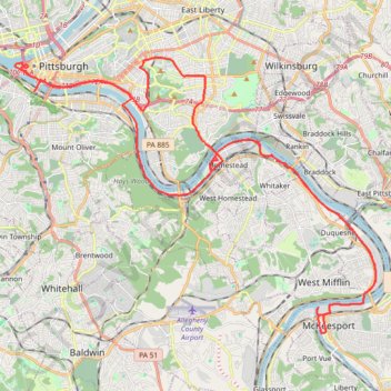
Four Rivers and Five Trails Loop
Interactive trail map
Thank you for supporting this site ❤️
Make a donation
Make a donation
Gear up for your next adventure:
As an Amazon Associate, this site earns from qualifying purchases at no extra cost to you.
Trail profile
- Distance: 62.6 Km
- Elevation gain: 687 m
- Maximum elevation: 339 m
- Elevation loss: 686 m
- Minimum elevation: 212 m
- Moving time: 10 h 1 m
- Moving speed: 6.2 Km/h
- Maximum speed: 24.0 Km/h
- Total time: 10 h 38 m
- Global speed: 5.9 Km/h
Thank you for supporting this site ❤️
Make a donation
Make a donation
Gear up for your next adventure:
As an Amazon Associate, this site earns from qualifying purchases at no extra cost to you.
About this trail
Name: Four Rivers and Five Trails Loop trail, distance, elevation, map, profile, GPS track
Coordinates: 40.34487 -80.01326 40.44457 -79.84158
Thank you for supporting this site ❤️
Make a donation
Make a donation
Gear up for your next adventure:
As an Amazon Associate, this site earns from qualifying purchases at no extra cost to you.
Other hiking, mountain biking, running and outdoor activity trails
Click on a trail to view its statistics, map and profile.
Fairhaven Greenway trails, Overbrook
United States > Pennsylvania > Allegheny County > Pittsburgh
Distance: 4.0 Km • Elevation gain: 113 m • Maximum elevation: 364 m