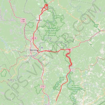
New River Gorge
- Distance: 206.3 Km
- Elevation gain: 5,337 m
- Maximum elevation: 851 m
- Elevation loss: 5,497 m
- Minimum elevation: 259 m
Interactive trail map
Trail profile
- Distance: 206.3 Km
- Elevation gain: 5,337 m
- Maximum elevation: 851 m
- Elevation loss: 5,497 m
- Minimum elevation: 259 m
About this trail
Name: New River Gorge trail, distance, elevation, map, profile, GPS track
Start: 1983, Hinton Road, Athens, Mercer County, West Virginia, 24712, United States (37.44551 -81.00120)
Coordinates: 37.44551 -81.19653 38.07797 -80.87418
Other hiking, mountain biking, running and outdoor activity trails
Click on a trail to view its statistics, map and profile.
Castle Rock Trail and Grandview Rim Trail Loop in New River Gorge National Park
United States > West Virginia > Raleigh County > Grandview
The loop hike on Castle Rock Trail and Grandview Rim Trail offers stunning views of the gorge and its dramatic sandstone cliffs. As you wind through the forest, you'll encounter breathtaking overlooks, especially near the Grandview Overlook, where you can take in the scenic horseshoe bend of the New River…
Distance: 1.7 Km • Elevation gain: 95 m • Maximum elevation: 761 m
Endless Wall Trail via Diamond Point Overlook in New River Gorge National Park
United States > West Virginia > Fayette County > Lansing
The Endless Wall Loop Trail leading to Diamond Point Overlook offers a delightful escape into nature, showcasing the stunning landscapes of the New River Gorge. As you meander through lush forests and along cliff edges, you’ll encounter breathtaking views of the river far below, with the towering sandstone…
Distance: 4.6 Km • Elevation gain: 134 m • Maximum elevation: 591 m
Turkey Spur Rock via Grandview Rim Trail in New River Gorge National Park and Preserve
United States > West Virginia > Raleigh County > Grandview
The Grandview Rim Trail leading to Turkey Spur Rock offers a truly rewarding hike in New River Gorge National Park. Starting at the Main Overlook, the trail winds through lush forests and along the rim of the gorge, providing frequent stops to admire breathtaking views of the deep river valley below. The…
Distance: 5.5 Km • Elevation gain: 150 m • Maximum elevation: 762 m
Long Point Trail in New River Gorge National Park and Preserve
United States > West Virginia > Fayette County
The Long Point Trail offers a delightful escape into nature, where every step brings you closer to breathtaking vistas of the expansive gorge below. As you traverse the well-maintained path, you’ll be greeted by the whispering winds through the trees and stunning views of the iconic New River Gorge Bridge,…
Distance: 5.0 Km • Elevation gain: 143 m • Maximum elevation: 593 m
Long Point Trail to Viewpoint in New River Gorge National Park and Preserve
United States > West Virginia > Fayette County
The Long Point Trail in New River Gorge National Park and Preserve offers hikers a scenic journey through lush forests, culminating in a breathtaking overlook of the New River Gorge Bridge. Along the way, the trail meanders through diverse woodlands, providing glimpses of local flora and fauna. The final…
Distance: 4.9 Km • Elevation gain: 145 m • Maximum elevation: 592 m
Diamond Point Overlook via Endless Wall Trail in New River Gorge National Park and Preserve
United States > West Virginia > Fayette County
The Endless Wall Trail to Diamond Point Overlook offers a breathtaking journey through lush forests, past cascading streams, and along dramatic cliff edges. As you hike, you’ll be rewarded with stunning views of the New River Gorge, where the majestic river flows far below and the vibrant landscape unfolds…
Distance: 3.5 Km • Elevation gain: 88 m • Maximum elevation: 555 m
New River Gorge National Park and Preserve
United States > West Virginia > Fayette County
Distance: 33.2 Km • Elevation gain: 1,090 m • Maximum elevation: 547 m
Eagle Point Trail in Bluestone State Park
United States > West Virginia > Summers County
Distance: 1.6 Km • Elevation gain: 160 m • Maximum elevation: 627 m