Make a donation
Gear up for your next adventure:
As an Amazon Associate, this site earns from qualifying purchases at no extra cost to you.
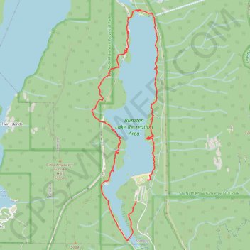
Buntzen Lake Trail
Interactive trail map
Make a donation
Gear up for your next adventure:
As an Amazon Associate, this site earns from qualifying purchases at no extra cost to you.
Trail profile
- Distance: 12.8 Km
- Elevation gain: 507 m
- Maximum elevation: 222 m
- Elevation loss: 512 m
- Minimum elevation: 129 m
Make a donation
Gear up for your next adventure:
As an Amazon Associate, this site earns from qualifying purchases at no extra cost to you.
About this trail
Name: Buntzen Lake Trail trail, distance, elevation, map, profile, GPS track
Coordinates: 49.33018 -122.86887 49.36588 -122.85316
Topography: Metro Vancouver Regional District topographic map, elevation, terrain
Make a donation
Gear up for your next adventure:
As an Amazon Associate, this site earns from qualifying purchases at no extra cost to you.
Other hiking, mountain biking, running and outdoor activity trails
Click on a trail to view its statistics, map and profile.
Buntzen Lake Loop
Canada > British Columbia > Metro Vancouver Regional District > Anmore
Distance: 11.5 Km • Elevation gain: 422 m • Maximum elevation: 270 m