Thank you for supporting this site ❤️
Make a donation
Make a donation
Gear up for your next adventure:
As an Amazon Associate, this site earns from qualifying purchases at no extra cost to you.
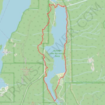
Buntzen Lake Loop
- Distance: 11.5 Km
- Elevation gain: 422 m
- Maximum elevation: 270 m
- Elevation loss: 421 m
- Minimum elevation: 129 m
- Moving time: 2 h 28 m
- Moving speed: 4.6 Km/h
- Maximum speed: 8.0 Km/h
- Total time: 2 h 38 m
- Global speed: 4.3 Km/h
Interactive trail map
Thank you for supporting this site ❤️
Make a donation
Make a donation
Gear up for your next adventure:
As an Amazon Associate, this site earns from qualifying purchases at no extra cost to you.
Trail profile
- Distance: 11.5 Km
- Elevation gain: 422 m
- Maximum elevation: 270 m
- Elevation loss: 421 m
- Minimum elevation: 129 m
- Moving time: 2 h 28 m
- Moving speed: 4.6 Km/h
- Maximum speed: 8.0 Km/h
- Total time: 2 h 38 m
- Global speed: 4.3 Km/h
Thank you for supporting this site ❤️
Make a donation
Make a donation
Gear up for your next adventure:
As an Amazon Associate, this site earns from qualifying purchases at no extra cost to you.
About this trail
Name: Buntzen Lake Loop trail, distance, elevation, map, profile, GPS track
Coordinates: 49.33018 -122.87007 49.36595 -122.85328
Topography: Metro Vancouver Regional District topographic map, elevation, terrain
Thank you for supporting this site ❤️
Make a donation
Make a donation
Gear up for your next adventure:
As an Amazon Associate, this site earns from qualifying purchases at no extra cost to you.
Other hiking, mountain biking, running and outdoor activity trails
Click on a trail to view its statistics, map and profile.