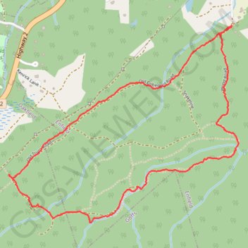
Wood Road Hiking Loop
Hiking, Wilderness, Backcountry
- Distance: 4.7 Km
- Elevation gain: 88 m
- Maximum elevation: 84 m
- Elevation loss: 87 m
- Minimum elevation: 21 m
- Moving time: 1 h 14 m
- Moving speed: 3.8 Km/h
- Maximum speed: 7.5 Km/h
- Total time: 1 h 41 m
- Global speed: 2.8 Km/h
Interactive trail map
Trail profile
- Distance: 4.7 Km
- Elevation gain: 88 m
- Maximum elevation: 84 m
- Elevation loss: 87 m
- Minimum elevation: 21 m
- Moving time: 1 h 14 m
- Moving speed: 3.8 Km/h
- Maximum speed: 7.5 Km/h
- Total time: 1 h 41 m
- Global speed: 2.8 Km/h
About this trail
Name: Wood Road Hiking Loop trail, distance, elevation, map, profile, GPS track
Coordinates: 44.90413 -63.55748 44.91504 -63.53955
Topography: Halifax County topographic map, elevation, terrain
Other hiking, mountain biking, running and outdoor activity trails
Click on a trail to view its statistics, map and profile.
Brookfield - Halifax
Canada > Nova Scotia > Municipality of Colchester > Brookfield
Distance: 92.2 Km • Elevation gain: 658 m • Maximum elevation: 66 m