Import a GPX file

Petes - Happy Valley - Exit

Nerang National Park. #Hiking #MTB #Loop #Nerang

  • Distance: 9.3 Km
  • Elevation gain: 197 m
  • Maximum elevation: 116 m
  • Elevation loss: 197 m
  • Minimum elevation: 12 m

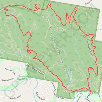
Interactive trail map

Trail profile

  • Distance: 9.3 Km
  • Elevation gain: 197 m
  • Maximum elevation: 116 m
  • Elevation loss: 197 m
  • Minimum elevation: 12 m

About this trail

Other hiking, mountain biking, running and outdoor activity trails

Click on a trail to view its statistics, map and profile.

Nerang National Park Loop

Australia > Queensland > Gold Coast City

#Hiking #MTB #Loop #Nerang

Distance: 17.6 Km • Elevation gain: 463 m • Maximum elevation: 186 m

Gear up for your next adventure:

🚲Heavy Duty Bike Lock - Secure your bike at the trailhead or during stops
💧Reusable Water Bottle - Durable water bottles for hydration on trails
🧼Biodegradable Camp Soap - Environmentally friendly cleaning for gear and body
🪑Ultralight Camping Stool - Compact seating for rest stops during long hikes
🔦LED Flashlight - Powerful and long-lasting flashlight for camping and emergencies

As an Amazon Associate, this site earns from qualifying purchases at no extra cost to you.