Import a GPX file

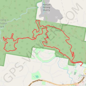
Nerang National Park Loop

#Hiking #MTB #Loop #Nerang

  • Distance: 17.6 Km
  • Elevation gain: 463 m
  • Maximum elevation: 186 m
  • Elevation loss: 463 m
  • Minimum elevation: 13 m

Interactive trail map

Trail profile

  • Distance: 17.6 Km
  • Elevation gain: 463 m
  • Maximum elevation: 186 m
  • Elevation loss: 463 m
  • Minimum elevation: 13 m

About this trail

Other hiking, mountain biking, running and outdoor activity trails

Click on a trail to view its statistics, map and profile.

Petes - Happy Valley - Exit

Australia > Queensland > Gold Coast City

Nerang National Park. #Hiking #MTB #Loop #Nerang

Distance: 9.3 Km • Elevation gain: 197 m • Maximum elevation: 116 m

Gear up for your next adventure:

Family Camping Tent - Spacious tent suitable for family camping trips
🧦Thermal Socks - Warm socks for winter hiking or camping
🔥Camping Stove - Portable stoves to cook outdoors with ease
🥾Waterproof Trail Shoes - Shoes designed to handle wet terrain
🥾Trekking Poles - Adjustable trekking poles to reduce knee stress and improve stability

As an Amazon Associate, this site earns from qualifying purchases at no extra cost to you.