Make a donation
Gear up for your next adventure:
As an Amazon Associate, this site earns from qualifying purchases at no extra cost to you.
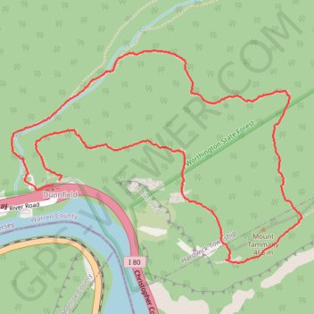
Mount Tammany Loop via Red Dot Trail, Delaware River Overlook and Blue Blaze in Worthington State Forest
The Mount Tammany Loop offers a captivating hiking experience with its stunning panoramic views of the Delaware River and the surrounding landscapes. The ascent via the Red Dot Trail features rocky terrain and steep inclines, rewarding hikers with scenic overlooks, particularly the dramatic vistas of Mount Minsi and the river below. The descent along the Blue Blaze Trail allows for a more gradual return, following the beautiful Dunnfield Creek, making this loop a memorable journey for outdoor enthusiasts. #Hiking #Loop #Mountain #Overlook #River #Forest #Nature
- Distance: 5.6 Km
- Elevation gain: 365 m
- Maximum elevation: 458 m
- Elevation loss: 370 m
- Minimum elevation: 100 m
- Moving time: 1 h 46 m
- Moving speed: 3.2 Km/h
- Maximum speed: 8.5 Km/h
- Total time: 1 h 52 m
- Global speed: 3.0 Km/h
Interactive trail map
Make a donation
Gear up for your next adventure:
As an Amazon Associate, this site earns from qualifying purchases at no extra cost to you.
Trail profile
- Distance: 5.6 Km
- Elevation gain: 365 m
- Maximum elevation: 458 m
- Elevation loss: 370 m
- Minimum elevation: 100 m
- Moving time: 1 h 46 m
- Moving speed: 3.2 Km/h
- Maximum speed: 8.5 Km/h
- Total time: 1 h 52 m
- Global speed: 3.0 Km/h
Make a donation
Gear up for your next adventure:
As an Amazon Associate, this site earns from qualifying purchases at no extra cost to you.
About this trail
Name: Mount Tammany Loop via Red Dot Trail, Delaware River Overlook and Blue Blaze in Worthington State Forest trail, distance, elevation, map, profile, GPS track
Coordinates: 40.96793 -75.12685 40.97809 -75.10845
Make a donation
Gear up for your next adventure:
As an Amazon Associate, this site earns from qualifying purchases at no extra cost to you.
Other hiking, mountain biking, running and outdoor activity trails
Click on a trail to view its statistics, map and profile.
Mount Tammany and Delaware River Overlook via Red Dot Trail in Worthington State Forest
United States > New Jersey > Warren County > Hardwick Township > Dunnfield
Hiking the Red Dot Trail offers an invigorating experience with stunning views of the Delaware River and the surrounding Kittatinny Mountains. As you ascend, you'll encounter rocky sections that provide rewarding overlooks, especially during the fall when the foliage is vibrant. This route not only highlights…
Distance: 4.1 Km • Elevation gain: 344 m • Maximum elevation: 437 m
Mount Minsi Loop Trail from Lenape Lake via Appalachian Trail, Lookout Rock and Lake Road in Delaware Water Gap National Recreation Area
United States > Pennsylvania > Monroe County > Delaware Water Gap
The Mount Minsi Loop Trail is a rewarding hiking experience featuring diverse landscapes and breathtaking viewpoints. As you ascend, the trail reveals stunning vistas such as the dramatic Lookout Rock and the expansive views from Minsi Lookout, which showcases the winding Delaware River and Mount Tammany…
Distance: 7.7 Km • Elevation gain: 348 m • Maximum elevation: 439 m
Make a donation
Gear up for your next adventure:
As an Amazon Associate, this site earns from qualifying purchases at no extra cost to you.