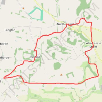
Aldro Farm loop
- Distance: 24.2 Km
- Elevation gain: 346 m
- Maximum elevation: 237 m
- Elevation loss: 346 m
- Minimum elevation: 54 m
- Moving time: 3 h 21 m
- Moving speed: 7.2 Km/h
- Maximum speed: 13.9 Km/h
- Total time: 3 h 28 m
- Global speed: 7.0 Km/h
Interactive trail map
Trail profile
- Distance: 24.2 Km
- Elevation gain: 346 m
- Maximum elevation: 237 m
- Elevation loss: 346 m
- Minimum elevation: 54 m
- Moving time: 3 h 21 m
- Moving speed: 7.2 Km/h
- Maximum speed: 13.9 Km/h
- Total time: 3 h 28 m
- Global speed: 7.0 Km/h
About this trail
Name: Aldro Farm loop trail, distance, elevation, map, profile, GPS track
Coordinates: 54.05454 -0.79001 54.10239 -0.67367
Other hiking, mountain biking, running and outdoor activity trails
Click on a trail to view its statistics, map and profile.
Settrington Beacon Loop from Norton-on-Derwent
United Kingdom > England > North Yorkshire > Norton-on-Derwent
Distance: 29.9 Km • Elevation gain: 412 m • Maximum elevation: 201 m
North Grimston Loop from Norton-on-Derwent
United Kingdom > England > North Yorkshire > Malton
Distance: 21.3 Km • Elevation gain: 200 m • Maximum elevation: 87 m
East Riding of Yorkshire Trail Running
United Kingdom > England > East Riding of Yorkshire
Distance: 33.5 Km • Elevation gain: 505 m • Maximum elevation: 235 m
Norton-on-Derwent south loop
United Kingdom > England > North Yorkshire > Norton-on-Derwent
Distance: 18.2 Km • Elevation gain: 247 m • Maximum elevation: 99 m
Norton to Langton loop
United Kingdom > England > North Yorkshire > Norton-on-Derwent
Ryedale Trail Running
Distance: 11.3 Km • Elevation gain: 203 m • Maximum elevation: 99 m
Loop hike from Burythorpe
United Kingdom > England > North Yorkshire > Kennythorpe
Distance: 13.1 Km • Elevation gain: 228 m • Maximum elevation: 237 m
Derwent Kennythorpe Loop
United Kingdom > England > North Yorkshire > Norton-on-Derwent
Distance: 16.0 Km • Elevation gain: 193 m • Maximum elevation: 99 m
Kennythorpe loop
United Kingdom > England > North Yorkshire > Norton-on-Derwent
Distance: 15.8 Km • Elevation gain: 186 m • Maximum elevation: 99 m
Menethorpe loop
United Kingdom > England > North Yorkshire > Norton-on-Derwent
Distance: 13.1 Km • Elevation gain: 162 m • Maximum elevation: 96 m
Derwent loop
United Kingdom > England > North Yorkshire > Norton-on-Derwent
Distance: 19.9 Km • Elevation gain: 229 m • Maximum elevation: 96 m
Acklam loop
United Kingdom > England > North Yorkshire > Norton-on-Derwent
Distance: 34.8 Km • Elevation gain: 551 m • Maximum elevation: 237 m