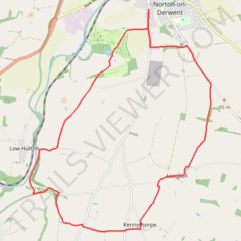
Kennythorpe loop
- Distance: 15.8 Km
- Elevation gain: 186 m
- Maximum elevation: 99 m
- Elevation loss: 186 m
- Minimum elevation: 19 m
- Moving time: 1 h 33 m
- Moving speed: 10.2 Km/h
- Maximum speed: 18.8 Km/h
- Total time: 1 h 33 m
- Global speed: 10.2 Km/h
Interactive trail map
Trail profile
- Distance: 15.8 Km
- Elevation gain: 186 m
- Maximum elevation: 99 m
- Elevation loss: 186 m
- Minimum elevation: 19 m
- Moving time: 1 h 33 m
- Moving speed: 10.2 Km/h
- Maximum speed: 18.8 Km/h
- Total time: 1 h 33 m
- Global speed: 10.2 Km/h
About this trail
Name: Kennythorpe loop trail, distance, elevation, map, profile, GPS track
Coordinates: 54.08228 -0.83375 54.12776 -0.77064
Other hiking, mountain biking, running and outdoor activity trails
Click on a trail to view its statistics, map and profile.
Settrington Beacon Loop from Norton-on-Derwent
United Kingdom > England > North Yorkshire > Norton-on-Derwent
Distance: 29.9 Km • Elevation gain: 412 m • Maximum elevation: 201 m
Appleton piggies
United Kingdom > England > North Yorkshire > Norton-on-Derwent
Distance: 37.7 Km • Elevation gain: 512 m • Maximum elevation: 117 m
Ryedale Trail Running
United Kingdom > England > North Yorkshire
Malton to Helmsley trot. #Running #Nature #Forest #Countryside
Distance: 30.0 Km • Elevation gain: 430 m • Maximum elevation: 117 m
North Grimston Loop from Norton-on-Derwent
United Kingdom > England > North Yorkshire > Malton
Distance: 21.3 Km • Elevation gain: 200 m • Maximum elevation: 87 m
Norton-on-Derwent south loop
United Kingdom > England > North Yorkshire > Norton-on-Derwent
Distance: 18.2 Km • Elevation gain: 247 m • Maximum elevation: 99 m
Norton to Langton loop
United Kingdom > England > North Yorkshire > Norton-on-Derwent
Ryedale Trail Running
Distance: 11.3 Km • Elevation gain: 203 m • Maximum elevation: 99 m
Derwent Kennythorpe Loop
United Kingdom > England > North Yorkshire > Norton-on-Derwent
Distance: 16.0 Km • Elevation gain: 193 m • Maximum elevation: 99 m
Norton-on-Derwent Loop
United Kingdom > England > North Yorkshire > Norton-on-Derwent
Distance: 10.0 Km • Elevation gain: 74 m • Maximum elevation: 59 m
Norton-on-Derwent Loop
United Kingdom > England > North Yorkshire > Norton-on-Derwent
Distance: 7.1 Km • Elevation gain: 42 m • Maximum elevation: 43 m
Westow out and back
United Kingdom > England > North Yorkshire > Burythorpe > Menethorpe
Distance: 8.0 Km • Elevation gain: 92 m • Maximum elevation: 81 m
Huttons Ambo loop
United Kingdom > England > North Yorkshire > Norton-on-Derwent
Distance: 10.5 Km • Elevation gain: 97 m • Maximum elevation: 56 m
Aldro Farm loop
United Kingdom > England > North Yorkshire > Birdsall
Distance: 24.2 Km • Elevation gain: 346 m • Maximum elevation: 237 m
Low Hutton loop
United Kingdom > England > North Yorkshire > Norton-on-Derwent
Distance: 10.8 Km • Elevation gain: 103 m • Maximum elevation: 56 m
Menethorpe loop
United Kingdom > England > North Yorkshire > Norton-on-Derwent
Distance: 13.1 Km • Elevation gain: 162 m • Maximum elevation: 96 m
Derwent loop
United Kingdom > England > North Yorkshire > Norton-on-Derwent
Distance: 19.9 Km • Elevation gain: 229 m • Maximum elevation: 96 m
Malton Loop
United Kingdom > England > North Yorkshire > Norton-on-Derwent
Distance: 7.2 Km • Elevation gain: 73 m • Maximum elevation: 61 m
Malton Loop
United Kingdom > England > North Yorkshire > Norton-on-Derwent
Distance: 12.6 Km • Elevation gain: 119 m • Maximum elevation: 78 m
Acklam loop
United Kingdom > England > North Yorkshire > Norton-on-Derwent
Distance: 34.8 Km • Elevation gain: 551 m • Maximum elevation: 237 m
Hutton loop
United Kingdom > England > North Yorkshire > Norton-on-Derwent
Distance: 12.6 Km • Elevation gain: 90 m • Maximum elevation: 56 m