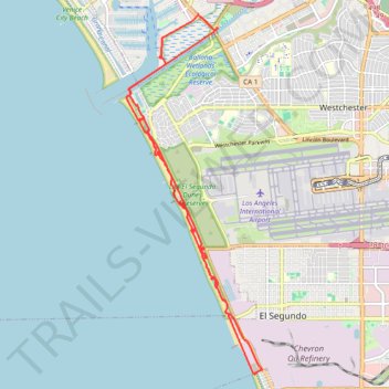
Dockweiler State Beach bike paths
- Distance: 23.3 Km
- Elevation gain: 190 m
- Maximum elevation: 34 m
- Elevation loss: 190 m
- Minimum elevation: 0 m
- Moving time: 1 h 22 m
- Moving speed: 16.9 Km/h
- Maximum speed: 37.2 Km/h
- Total time: 1 h 23 m
- Global speed: 16.8 Km/h
Interactive trail map
Trail profile
- Distance: 23.3 Km
- Elevation gain: 190 m
- Maximum elevation: 34 m
- Elevation loss: 190 m
- Minimum elevation: 0 m
- Moving time: 1 h 22 m
- Moving speed: 16.9 Km/h
- Maximum speed: 37.2 Km/h
- Total time: 1 h 23 m
- Global speed: 16.8 Km/h
About this trail
Name: Dockweiler State Beach bike paths trail, distance, elevation, map, profile, GPS track
Coordinates: 33.90497 -118.45427 33.97882 -118.42075
Other hiking, mountain biking, running and outdoor activity trails
Click on a trail to view its statistics, map and profile.