Make a donation
Gear up for your next adventure:
As an Amazon Associate, this site earns from qualifying purchases at no extra cost to you.
Whiteshell - Kenora
#Bike #Whiteshell #Kenora
- Distance: 69.2 Km
- Elevation gain: 577 m
- Maximum elevation: 382 m
- Elevation loss: 571 m
- Minimum elevation: 322 m
Interactive trail map
Make a donation
Gear up for your next adventure:
As an Amazon Associate, this site earns from qualifying purchases at no extra cost to you.
Trail profile
- Distance: 69.2 Km
- Elevation gain: 577 m
- Maximum elevation: 382 m
- Elevation loss: 571 m
- Minimum elevation: 322 m
Make a donation
Gear up for your next adventure:
As an Amazon Associate, this site earns from qualifying purchases at no extra cost to you.
About this trail
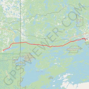
Name: Whiteshell - Kenora trail, distance, elevation, map, profile, GPS track
Coordinates: 49.68395 -95.33106 49.77090 -94.47914
Topography: Unorganized Division No. 1 topographic map, elevation, terrain
Make a donation
Gear up for your next adventure:
As an Amazon Associate, this site earns from qualifying purchases at no extra cost to you.
Other hiking, mountain biking, running and outdoor activity trails
Click on a trail to view its statistics, map and profile.
Kenora - Vermilion Bay
Canada > Ontario > Kenora District > Kenora
Distance: 87.1 Km • Elevation gain: 894 m • Maximum elevation: 452 m
Richer - Whiteshell
Canada > Rural Municipality of Ste. Anne > Richer
#Bike #Richer #Whiteshell
Distance: 88.6 Km • Elevation gain: 126 m • Maximum elevation: 340 m
Tunnel Island Loop - Bison Trail A
Canada > Ontario > Kenora District > Kenora
Distance: 6.4 Km • Elevation gain: 116 m • Maximum elevation: 347 m
Make a donation
Gear up for your next adventure:
As an Amazon Associate, this site earns from qualifying purchases at no extra cost to you.
Ernie's Trail and Honeymoon Trail
Canada > Ontario > Kenora District > Unorganized Kenora District
Distance: 4.4 Km • Elevation gain: 70 m • Maximum elevation: 342 m
Mushroom Trail
Canada > Ontario > Kenora District > Unorganized Kenora District
Distance: 8.6 Km • Elevation gain: 117 m • Maximum elevation: 357 m