Thank you for supporting this site ❤️
Make a donation
Make a donation
Gear up for your next adventure:
As an Amazon Associate, this site earns from qualifying purchases at no extra cost to you.
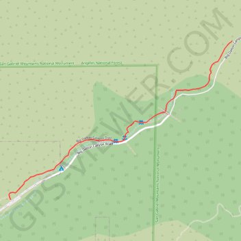
Big Dalton Canyon Trail
Hike on the Big Dalton Canyon Trail in the Big Dalton Canyon Wilderness Park, the San Gabriel Mountains National Monument and the Angeles National Forest. #Hiking #Canyon #Mountain #Nature #Forest #Angeles
- Distance: 1.7 Km
- Elevation gain: 78 m
- Maximum elevation: 439 m
- Elevation loss: 14 m
- Minimum elevation: 374 m
Interactive trail map
Thank you for supporting this site ❤️
Make a donation
Make a donation
Gear up for your next adventure:
As an Amazon Associate, this site earns from qualifying purchases at no extra cost to you.
Trail profile
- Distance: 1.7 Km
- Elevation gain: 78 m
- Maximum elevation: 439 m
- Elevation loss: 14 m
- Minimum elevation: 374 m
Thank you for supporting this site ❤️
Make a donation
Make a donation
Gear up for your next adventure:
As an Amazon Associate, this site earns from qualifying purchases at no extra cost to you.
About this trail
Name: Big Dalton Canyon Trail trail, distance, elevation, map, profile, GPS track
Coordinates: 34.15873 -117.82866 34.16639 -117.81564
Thank you for supporting this site ❤️
Make a donation
Make a donation
Gear up for your next adventure:
As an Amazon Associate, this site earns from qualifying purchases at no extra cost to you.