Thank you for supporting this site ❤️
Make a donation
Make a donation
Gear up for your next adventure:
As an Amazon Associate, this site earns from qualifying purchases at no extra cost to you.
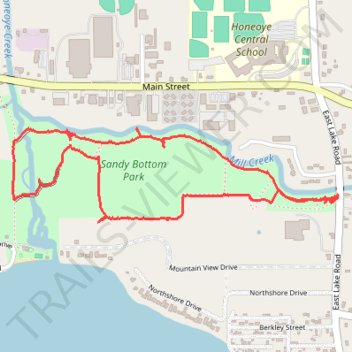
Sandy Bottom Park Nature Loop Trail
- Distance: 4.1 Km
- Elevation gain: 25 m
- Maximum elevation: 262 m
- Elevation loss: 25 m
- Minimum elevation: 245 m
- Moving time: 1 h 15 m
- Moving speed: 3.2 Km/h
- Maximum speed: 5.0 Km/h
- Total time: 2 h 49 m
- Global speed: 1.4 Km/h
Interactive trail map
Thank you for supporting this site ❤️
Make a donation
Make a donation
Gear up for your next adventure:
As an Amazon Associate, this site earns from qualifying purchases at no extra cost to you.
Trail profile
- Distance: 4.1 Km
- Elevation gain: 25 m
- Maximum elevation: 262 m
- Elevation loss: 25 m
- Minimum elevation: 245 m
- Moving time: 1 h 15 m
- Moving speed: 3.2 Km/h
- Maximum speed: 5.0 Km/h
- Total time: 2 h 49 m
- Global speed: 1.4 Km/h
Thank you for supporting this site ❤️
Make a donation
Make a donation
Gear up for your next adventure:
As an Amazon Associate, this site earns from qualifying purchases at no extra cost to you.
About this trail
Name: Sandy Bottom Park Nature Loop Trail trail, distance, elevation, map, profile, GPS track
Coordinates: 42.78473 -77.51477 42.78807 -77.49899
Thank you for supporting this site ❤️
Make a donation
Make a donation
Gear up for your next adventure:
As an Amazon Associate, this site earns from qualifying purchases at no extra cost to you.