Make a donation
Gear up for your next adventure:
As an Amazon Associate, this site earns from qualifying purchases at no extra cost to you.
Монблан
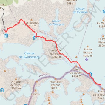
- Distance: 7.9 Km
- Elevation gain: 2,283 m
- Maximum elevation: 4,611 m
- Elevation loss: 39 m
- Minimum elevation: 2,356 m
Interactive trail map
Make a donation
Gear up for your next adventure:
As an Amazon Associate, this site earns from qualifying purchases at no extra cost to you.
Trail profile
- Distance: 7.9 Km
- Elevation gain: 2,283 m
- Maximum elevation: 4,611 m
- Elevation loss: 39 m
- Minimum elevation: 2,356 m
Make a donation
Gear up for your next adventure:
As an Amazon Associate, this site earns from qualifying purchases at no extra cost to you.
About this trail
Name: Монблан trail, distance, elevation, map, profile, GPS track
Coordinates: 45.83427 6.79806 45.86295 6.85903
Make a donation
Gear up for your next adventure:
As an Amazon Associate, this site earns from qualifying purchases at no extra cost to you.
Other hiking, mountain biking, running and outdoor activity trails
Click on a trail to view its statistics, map and profile.
Ultra-Trail du Mont Blanc (UTMB)
France > Auvergne-Rhône-Alpes > Upper Savoy > Chamonix-Mont-Blanc
Distance: 167.8 Km • Elevation gain: 10,450 m • Maximum elevation: 2,535 m
Монблан
France > Auvergne-Rhône-Alpes > Upper Savoy > Saint-Gervais-les-Bains
Distance: 7.9 Km • Elevation gain: 2,283 m • Maximum elevation: 4,611 m
TTdMB-1 Tour Du Mont Blanc - Itinéraire Principal
France > Auvergne-Rhône-Alpes > Upper Savoy > Chamonix-Mont-Blanc
Distance: 166.0 Km • Elevation gain: 10,535 m • Maximum elevation: 2,537 m
UTMB 2020
France > Auvergne-Rhône-Alpes > Upper Savoy > Chamonix-Mont-Blanc > Les Bossons
Total: 171.3km
Distance: 168.1 Km • Elevation gain: 10,526 m • Maximum elevation: 2,574 m
Make a donation
Gear up for your next adventure:
As an Amazon Associate, this site earns from qualifying purchases at no extra cost to you.
Mont Blanc par les Grands Mulets
France > Auvergne-Rhône-Alpes > Upper Savoy > Chamonix-Mont-Blanc > Les Bossons
Distance: 25.6 Km • Elevation gain: 3,832 m • Maximum elevation: 4,799 m
PT23DS2 Lörrach → Cadaqués
Germany > Baden-Württemberg > Landkreis Lörrach > Lörrach (Kernstadt)
Distance: 1,050.7 Km • Elevation gain: 13,130 m • Maximum elevation: 1,505 m