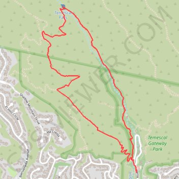
Temescal Falls
Interactive trail map
Trail profile
- Distance: 5.1 Km
- Elevation gain: 284 m
- Maximum elevation: 347 m
- Elevation loss: 284 m
- Minimum elevation: 107 m
About this trail
Name: Temescal Falls trail, distance, elevation, map, profile, GPS track
Coordinates: 34.05364 -118.53869 34.06821 -118.52868
Other hiking, mountain biking, running and outdoor activity trails
Click on a trail to view its statistics, map and profile.
Skull Rock and Temescal Falls Loop in Topanga State Park
United States > California > Los Angeles County > Los Angeles
The Skull Rock and Temescal Falls Loop in Topanga State Park offers hikers a diverse experience, featuring lush shaded trails, exposed steep climbs, and gorgeous ocean views. Along the route, you'll encounter the intriguing Skull Rock formation, which resembles a skull, and a small cascade known as Temescal…
Distance: 6.7 Km • Elevation gain: 335 m • Maximum elevation: 427 m