Thank you for supporting this site ❤️
Make a donation
Make a donation
Gear up for your next adventure:
As an Amazon Associate, this site earns from qualifying purchases at no extra cost to you.
Manly Dam
Interactive trail map
Thank you for supporting this site ❤️
Make a donation
Make a donation
Gear up for your next adventure:
As an Amazon Associate, this site earns from qualifying purchases at no extra cost to you.
Trail profile
- Distance: 9.1 Km
- Elevation gain: 198 m
- Maximum elevation: 125 m
- Elevation loss: 194 m
- Minimum elevation: 33 m
Thank you for supporting this site ❤️
Make a donation
Make a donation
Gear up for your next adventure:
As an Amazon Associate, this site earns from qualifying purchases at no extra cost to you.
About this trail
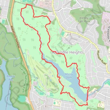
Name: Manly Dam trail, distance, elevation, map, profile, GPS track
Coordinates: -33.78407 151.23543 -33.75847 151.25613
Thank you for supporting this site ❤️
Make a donation
Make a donation
Gear up for your next adventure:
As an Amazon Associate, this site earns from qualifying purchases at no extra cost to you.
Other hiking, mountain biking, running and outdoor activity trails
Click on a trail to view its statistics, map and profile.
Manly Dam MTB Loop Trail
Australia > New South Wales > Sydney
Distance: 13.2 Km • Elevation gain: 188 m • Maximum elevation: 148 m