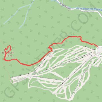
Mount Tecumseh
Starting from the Waterville Valley Ski Area parking area in White Mountain National Forest, the route follows the Mount Tecumseh Trail into mixed mountain forest, staying close to the Tecumseh Brook corridor before crossing the brook and climbing away from the ski slopes.
The ascent becomes rockier and more enclosed among hardwoods and conifers, with occasional glimpses toward Waterville Valley, then reaches the Tecumseh–Sosman junction and the short summit loop around Mount Tecumseh.
On the return, Sosman Trail and the upper ridge area add lookout points toward the resort and surrounding White Mountains before the route drops back through the forest and brook valley to the trailhead.
#Hiking #Mountain #Forest #Nature #Summit #Woodland #Brook
- Distance: 7.7 Km
- Elevation gain: 667 m
- Maximum elevation: 1,196 m
- Elevation loss: 671 m
- Minimum elevation: 561 m
- Moving time: 2 h 18 m
- Moving speed: 3.3 Km/h
- Maximum speed: 5.0 Km/h
- Total time: 2 h 34 m
- Global speed: 3.0 Km/h
Interactive trail map
Trail profile
- Distance: 7.7 Km
- Elevation gain: 667 m
- Maximum elevation: 1,196 m
- Elevation loss: 671 m
- Minimum elevation: 561 m
- Moving time: 2 h 18 m
- Moving speed: 3.3 Km/h
- Maximum speed: 5.0 Km/h
- Total time: 2 h 34 m
- Global speed: 3.0 Km/h
About this trail
Name: Mount Tecumseh trail, distance, elevation, map, profile, GPS track
Coordinates: 43.96224 -71.55783 43.96917 -71.52672
Other hiking, mountain biking, running and outdoor activity trails
Click on a trail to view its statistics, map and profile.
Mount Tecumseh Trail in White Mountain National Forest
United States > New Hampshire > Grafton County > Waterville Valley
The Mount Tecumseh Trail offers a scenic yet challenging route through dense woodlands, with distinct shifts in landscape as hikers ascend. Starting with a gentle, moss-covered forest floor and occasional streams, the trail becomes steeper as it winds through fir and spruce trees, offering occasional glimpses…
Distance: 7.7 Km • Elevation gain: 660 m • Maximum elevation: 1,197 m
Mount Tecumseh Trail in White Mountain National Forest
United States > New Hampshire > Grafton County > Waterville Valley
The Mount Tecumseh Trail offers a scenic yet challenging hike with a steady ascent through dense forests, accompanied by the soothing sounds of nearby streams. Along the way, hikers can enjoy occasional views, particularly near the summit, which provides sweeping vistas to the north and east of the White…
Distance: 3.7 Km • Elevation gain: 643 m • Maximum elevation: 1,197 m
Mount Tecumseh Trail in White Mountain National Forest
United States > New Hampshire > Grafton County > Waterville Valley
The Mount Tecumseh Trail in New Hampshire's White Mountain National Forest offers hikers a journey through dense, moss-covered forests adorned with ferns and birch trees. As the trail ascends, it provides occasional viewpoints overlooking the Waterville Valley Ski Resort and distant peaks like Mount…
Distance: 7.5 Km • Elevation gain: 651 m • Maximum elevation: 1,197 m