Make a donation
Gear up for your next adventure:
As an Amazon Associate, this site earns from qualifying purchases at no extra cost to you.
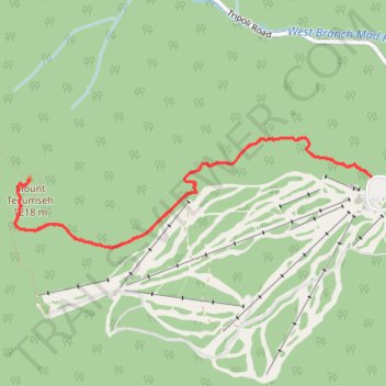
Mount Tecumseh Trail in White Mountain National Forest
The Mount Tecumseh Trail in New Hampshire's White Mountain National Forest offers hikers a journey through dense, moss-covered forests adorned with ferns and birch trees. As the trail ascends, it provides occasional viewpoints overlooking the Waterville Valley Ski Resort and distant peaks like Mount Moosilauke. Upon reaching the summit, hikers are rewarded with panoramic views of the Sandwich Range and parts of the Presidential Range. #Hiking #Mountain #Forest #Nature #Overlook
- Distance: 7.5 Km
- Elevation gain: 651 m
- Maximum elevation: 1,197 m
- Elevation loss: 651 m
- Minimum elevation: 564 m
- Moving time: 1 h 55 m
- Moving speed: 3.9 Km/h
- Maximum speed: 11.4 Km/h
- Total time: 2 h 15 m
- Global speed: 3.3 Km/h
Interactive trail map
Make a donation
Gear up for your next adventure:
As an Amazon Associate, this site earns from qualifying purchases at no extra cost to you.
Trail profile
- Distance: 7.5 Km
- Elevation gain: 651 m
- Maximum elevation: 1,197 m
- Elevation loss: 651 m
- Minimum elevation: 564 m
- Moving time: 1 h 55 m
- Moving speed: 3.9 Km/h
- Maximum speed: 11.4 Km/h
- Total time: 2 h 15 m
- Global speed: 3.3 Km/h
Make a donation
Gear up for your next adventure:
As an Amazon Associate, this site earns from qualifying purchases at no extra cost to you.
About this trail
Name: Mount Tecumseh Trail in White Mountain National Forest trail, distance, elevation, map, profile, GPS track
Coordinates: 43.96230 -71.55781 43.96915 -71.52686
Make a donation
Gear up for your next adventure:
As an Amazon Associate, this site earns from qualifying purchases at no extra cost to you.
Other hiking, mountain biking, running and outdoor activity trails
Click on a trail to view its statistics, map and profile.
Mount Tecumseh
United States > New Hampshire > Grafton County > Waterville Valley
Starting from the Waterville Valley Ski Area parking area in White Mountain National Forest, the route follows the Mount Tecumseh Trail into mixed mountain forest, staying close to the Tecumseh Brook corridor before crossing the brook and climbing away from the ski slopes. The ascent becomes rockier and more…
Distance: 7.7 Km • Elevation gain: 667 m • Maximum elevation: 1,196 m
Mount Tecumseh Trail in White Mountain National Forest
United States > New Hampshire > Grafton County > Waterville Valley
The Mount Tecumseh Trail offers a scenic yet challenging route through dense woodlands, with distinct shifts in landscape as hikers ascend. Starting with a gentle, moss-covered forest floor and occasional streams, the trail becomes steeper as it winds through fir and spruce trees, offering occasional glimpses…
Distance: 7.7 Km • Elevation gain: 660 m • Maximum elevation: 1,197 m
Mount Tecumseh Trail in White Mountain National Forest
United States > New Hampshire > Grafton County > Waterville Valley
The Mount Tecumseh Trail offers a scenic yet challenging hike with a steady ascent through dense forests, accompanied by the soothing sounds of nearby streams. Along the way, hikers can enjoy occasional views, particularly near the summit, which provides sweeping vistas to the north and east of the White…
Distance: 3.7 Km • Elevation gain: 643 m • Maximum elevation: 1,197 m
Make a donation
Gear up for your next adventure:
As an Amazon Associate, this site earns from qualifying purchases at no extra cost to you.