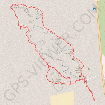
Roques de Garcia - El Teide
- Distance: 5.5 Km
- Elevation gain: 254 m
- Maximum elevation: 2,175 m
- Elevation loss: 252 m
- Minimum elevation: 2,016 m
Interactive trail map
Trail profile
- Distance: 5.5 Km
- Elevation gain: 254 m
- Maximum elevation: 2,175 m
- Elevation loss: 252 m
- Minimum elevation: 2,016 m
About this trail
Name: Roques de Garcia - El Teide trail, distance, elevation, map, profile, GPS track
Start: Mirador de la Ruleta, La Orotava, Santa Cruz de Tenerife, Canary Islands, Spain (28.22321 -16.63100)
Coordinates: 28.22068 -16.64089 28.23204 -16.62967
Other hiking, mountain biking, running and outdoor activity trails
Click on a trail to view its statistics, map and profile.
LONG TRAIL GR - 131 TENERIFE (CANARY ISLANDS) GR131 GR 131|trackspotting.com
Spain > El Rosario > La Esperanza
Distance: 87.7 Km • Elevation gain: 4,437 m • Maximum elevation: 2,404 m